Longquan geodata
Longquan (Yunnan) is a seat of a third-order administrative division; located in China in Asia/Shanghai (GMT+8) time zone. With population of 91,534 people, there are 461 cities with bigger population in this country. Compared to other cities in China, 87.8% of cities are located further ↑North; 92.7% of cities are located further →East and 92.1% of cities have lower elevation than Longquan. Note1


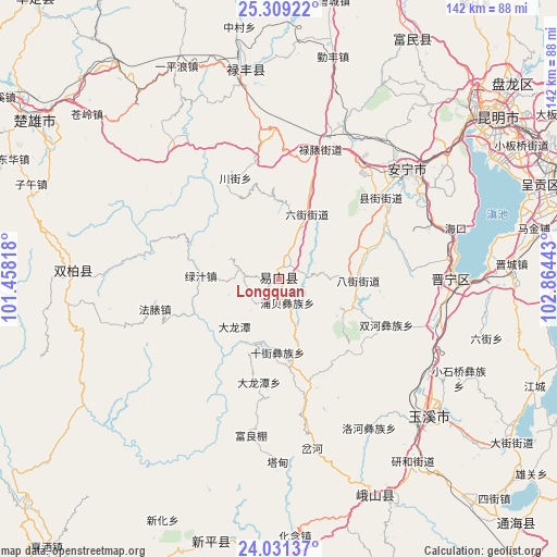
Longquan GPS coordinates[2]
24° 40' 18.948" North, 102° 9' 40.68" East
| Map corner | latitude | longitude |
|---|---|---|
| Upper-left | 25.30922°, | 101.45818° |
| Center: | 24.67193°, | 102.1613° |
| Lower-right: | 24.03137°, | 102.86443° |
| Map W x H: | 142.1×142.1 km | = 88.3×88.3mi |
| max Lat: | 53.31946° ⇑87.8% North |
| Longquan: | 24.67193° |
| min Lat: | ⇓12.2% South 18.22056° |
| min Long | Longquan | max Long |
| 75.07348° | 102.1613° | 134.28917° |
| W 7.3%⇐ | ⇒92.7% E |
Elevation
Elevation of Longquan is 1591 m = 5220 ft, and this is 1106.2 m = 3629 ft above average elevation for this country.
| Max E: |
5622 m = 18445 ft | 7.9% |
| Longquan | 1591 m 5220 ft | |
| Avg. | 484.8 m = 1591 ft | |
Min E: |
-3 m = -10 ft | 92.1% |
See also: Longquan elevation on elevation.city.
Geographical zone
Longquan is located in North temperate zone (between Tropic of Cancer and the Arctic Circle). Distance of this Northern Tropic circle is 137.3 km =85.3 mi to South.| Distance of | km | miles | from Longquan |
|---|---|---|---|
| North Pole | 7263.8 | 4513.5 | to North |
| Arctic Circle | 4657.9 | 2894.3 | to North |
| Tropic Cancer | 137.3 | 85.3 | to South |
| Equator | 2743.3 | 1704.6 | to South |


Nearby cities:
15 places around Longquan: (largest is in red/bold)
• Bajie
20.2 km =12.6 mi,  90°
90°
• Dalongtan
26.8 km =16.7 mi,  191°
191°
• Dengzishan
27.8 km =17.3 mi,  335°
335°
• Dianzhong
30.4 km =18.9 mi,  167°
167°
• Liujie
17.9 km =11.1 mi,  22°
22°
• Lubiaojie
35.5 km =22.1 mi, 17°
• Mingyihe
29.8 km =18.5 mi,  64°
64°
• Shijie
18.9 km =11.7 mi,  180°
180°
• Shuanghejie
30.2 km =18.8 mi,  112°
112°
• Tongchang
13.6 km =8.5 mi,  289°
289°
• Tuguan
30.7 km =19.1 mi,  7°
7°
• Xianjie
33.5 km =20.8 mi,  51°
51°
• Xiaojie
21.6 km =13.4 mi,  352°
352°
• Xinjiezi
6.5 km =4 mi,  161°
161°
• Xiyang
26.6 km =16.5 mi,  150°
150°
Sources, notices
• [Note1] Compared only with cities in China existing in our database
• [Src1] Map data: © OpenStreetMap contributors (CC-BY-SA)
• [Src2] Other city data from geonames.org with taken over terms of usage.
• [Src3] Geographical zone / Annual Mean Temperature by Robert A. Rohde @ Wikipedia
