Tongchang geodata
Tongchang (Yunnan) is a seat of a fourth-order administrative division; located in China in Asia/Shanghai (GMT+8) time zone. In our database, there are 1268 cities with bigger population. Compared to other cities in China, 87.6% of cities are located further ↑North; 92.8% of cities are located further →East and 95.1% of cities have lower elevation than Tongchang. Note1


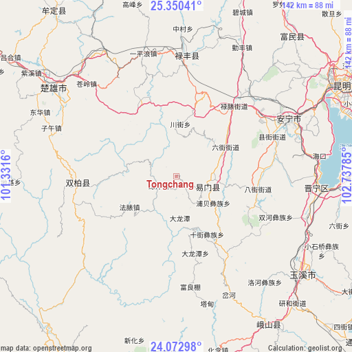
Tongchang GPS coordinates[2]
24° 42' 47.988" North, 102° 2' 4.992" East
| Map corner | latitude | longitude |
|---|---|---|
| Upper-left | 25.35041°, | 101.3316° |
| Center: | 24.71333°, | 102.03472° |
| Lower-right: | 24.07298°, | 102.73785° |
| Map W x H: | 142×142 km | = 88.2×88.2mi |
| max Lat: | 53.31946° ⇑87.6% North |
| Tongchang: | 24.71333° |
| min Lat: | ⇓12.4% South 18.22056° |
| min Long | Tongchang | max Long |
| 75.07348° | 102.03472° | 134.28917° |
| W 7.2%⇐ | ⇒92.8% E |
Elevation
Elevation of Tongchang is 2149 m = 7051 ft, and this is 1664.2 m = 5460 ft above average elevation for this country.
| Max E: |
5622 m = 18445 ft | 4.9% |
| Tongchang | 2149 m 7051 ft | |
| Avg. | 484.8 m = 1591 ft | |
Min E: |
-3 m = -10 ft | 95.1% |
See also: China elevation on elevation.city.
Geographical zone
Tongchang is located in North temperate zone (between Tropic of Cancer and the Arctic Circle). Distance of this Northern Tropic circle is 141.9 km =88.2 mi to South.| Distance of | km | miles | from Tongchang |
|---|---|---|---|
| North Pole | 7259.2 | 4510.7 | to North |
| Arctic Circle | 4653.3 | 2891.4 | to North |
| Tropic Cancer | 141.9 | 88.2 | to South |
| Equator | 2747.9 | 1707.5 | to South |


Nearby cities:
15 places around Tongchang: (largest is in red/bold)
• Bajie
33.3 km =20.7 mi,  98°
98°
• Dalongtan
31.7 km =19.7 mi,  166°
166°
• Dengzishan
20.6 km =12.8 mi,  2°
2°
• Dianzhong
39.3 km =24.4 mi,  150°
150°
• Liujie
23 km =14.3 mi,  58°
58°
• Longquan
13.6 km =8.5 mi,  109°
109°
• Lubiaojie
37.5 km =23.3 mi,  38°
38°
• Mingyihe
40.6 km =25.2 mi,  78°
78°
• Shijie
26.6 km =16.5 mi, 151°
• Tuguan
30.7 km =19.1 mi,  32°
32°
• Tuodian
40.9 km =25.4 mi,  262°
262°
• Xianjie
42.3 km =26.3 mi,  67°
67°
• Xiaojie
19.6 km =12.2 mi, 31°
• Xinjiezi
18.3 km =11.4 mi,  125°
125°
• Xiyang
37.9 km =23.5 mi,  136°
136°
Sources, notices
• [Note1] Compared only with cities in China existing in our database
• [Src1] Map data: © OpenStreetMap contributors (CC-BY-SA)
• [Src2] Other city data from geonames.org with taken over terms of usage.
• [Src3] Geographical zone / Annual Mean Temperature by Robert A. Rohde @ Wikipedia
