Libao geodata
Libao (Jiangsu) is a seat of a fourth-order administrative division; located in China in Asia/Shanghai (GMT+8) time zone. In our database, there are 1268 cities with bigger population. Compared to other cities in China, 64.3% of cities are located further ↓South; 86.1% of cities are located further ←West and 98.9% of cities have higher elevation than Libao. Note1


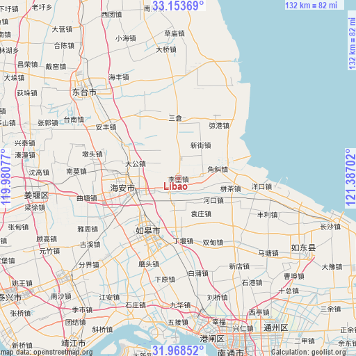
Libao GPS coordinates[2]
32° 33' 47.016" North, 120° 41' 2.004" East
| Map corner | latitude | longitude |
|---|---|---|
| Upper-left | 33.15369°, | 119.98077° |
| Center: | 32.56306°, | 120.68389° |
| Lower-right: | 31.96852°, | 121.38702° |
| Map W x H: | 131.8×131.8 km | = 81.9×81.9mi |
| max Lat: | 53.31946° ⇑35.7% North |
| Libao: | 32.56306° |
| min Lat: | ⇓64.3% South 18.22056° |
| min Long | Libao | max Long |
| 75.07348° | 120.68389° | 134.28917° |
| W 86.1%⇐ | ⇒13.9% E |
Elevation
Elevation of Libao is 3 m = 10 ft, and this is 481.8 m = 1581 ft below average elevation for this country.
| Max E: |
5622 m = 18445 ft | 98.9% |
| Avg. | 484.8 m = 1591 ft | |
| Libao | 3 m = 10 ft | |
Min E: |
-3 m = -10 ft | 1.1% |
See also: China elevation on elevation.city.
Geographical zone
Libao is located in North temperate zone (between Tropic of Cancer and the Arctic Circle). Distance of this Northern Tropic circle is 1014.8 km =630.6 mi to South.| Distance of | km | miles | from Libao |
|---|---|---|---|
| North Pole | 6386.4 | 3968.3 | to North |
| Arctic Circle | 3780.5 | 2349.1 | to North |
| Tropic Cancer | 1014.8 | 630.6 | to South |
| Equator | 3620.7 | 2249.8 | to South |


Nearby cities:
15 places around Libao: (largest is in red/bold)
• Bingcha
20 km =12.4 mi,  102°
102°
• Chaiwan
17.8 km =11.1 mi,  229°
229°
• Chaoqiao
1.7 km =1.1 mi,  213°
213°
• Chengdong
17.6 km =10.9 mi,  258°
258°
• Dagong
16.5 km =10.3 mi,  290°
290°
• Dongchen
18.4 km =11.4 mi,  192°
192°
• Fudong
21 km =13 mi,  325°
325°
• Hekou
15.2 km =9.4 mi,  120°
120°
• Jiaoxie
9.4 km =5.8 mi,  83°
83°
• Tangyang
8.3 km =5.2 mi,  4°
4°
• Xichang
9.6 km =6 mi,  243°
243°
• Xinjie
15.4 km =9.6 mi,  32°
32°
• Xue’an
11.6 km =7.2 mi,  177°
177°
• Xuhe
18.7 km =11.6 mi,  347°
347°
• Yuanzhuang
15.3 km =9.5 mi,  146°
146°
Sources, notices
• [Note1] Compared only with cities in China existing in our database
• [Src1] Map data: © OpenStreetMap contributors (CC-BY-SA)
• [Src2] Other city data from geonames.org with taken over terms of usage.
• [Src3] Geographical zone / Annual Mean Temperature by Robert A. Rohde @ Wikipedia
