Tangyang geodata
Tangyang (Jiangsu) is a seat of a fourth-order administrative division; located in China in Asia/Shanghai (GMT+8) time zone. In our database, there are 1268 cities with bigger population. Compared to other cities in China, 64.5% of cities are located further ↓South; 86.2% of cities are located further ←West and 94.3% of cities have higher elevation than Tangyang. Note1


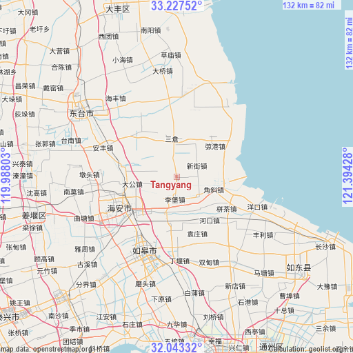
Tangyang GPS coordinates[2]
32° 38' 14.568" North, 120° 41' 28.14" East
| Map corner | latitude | longitude |
|---|---|---|
| Upper-left | 33.22752°, | 119.98803° |
| Center: | 32.63738°, | 120.69115° |
| Lower-right: | 32.04332°, | 121.39428° |
| Map W x H: | 131.7×131.7 km | = 81.8×81.8mi |
| max Lat: | 53.31946° ⇑35.5% North |
| Tangyang: | 32.63738° |
| min Lat: | ⇓64.5% South 18.22056° |
| min Long | Tangyang | max Long |
| 75.07348° | 120.69115° | 134.28917° |
| W 86.2%⇐ | ⇒13.8% E |
Elevation
Elevation of Tangyang is 7 m = 23 ft, and this is 477.8 m = 1568 ft below average elevation for this country.
| Max E: |
5622 m = 18445 ft | 94.3% |
| Avg. | 484.8 m = 1591 ft | |
| Tangyang | 7 m = 23 ft | |
Min E: |
-3 m = -10 ft | 5.7% |
See also: China elevation on elevation.city.
Geographical zone
Tangyang is located in North temperate zone (between Tropic of Cancer and the Arctic Circle). Distance of this Northern Tropic circle is 1023 km =635.7 mi to South.| Distance of | km | miles | from Tangyang |
|---|---|---|---|
| North Pole | 6378.1 | 3963.2 | to North |
| Arctic Circle | 3772.2 | 2343.9 | to North |
| Tropic Cancer | 1023 | 635.7 | to South |
| Equator | 3628.9 | 2254.9 | to South |


Nearby cities:
15 places around Tangyang: (largest is in red/bold)
• Chaoqiao
9.8 km =6.1 mi,  189°
189°
• Chengdong
21.4 km =13.3 mi,  236°
236°
• Dagong
16.4 km =10.2 mi,  261°
261°
• Fudong
15.4 km =9.6 mi,  306°
306°
• Fu’an
20.8 km =12.9 mi,  282°
282°
• Hekou
20.3 km =12.6 mi,  142°
142°
• Jianggang
18.4 km =11.4 mi,  51°
51°
• Jiaoxie
11.3 km =7 mi,  129°
129°
• Libao
8.3 km =5.2 mi,  184°
184°
• Sancang
14.6 km =9.1 mi,  350°
350°
• Xichang
15.6 km =9.7 mi,  216°
216°
• Xinjie
9 km =5.6 mi,  58°
58°
• Xinnong
14 km =8.7 mi,  26°
26°
• Xue’an
19.9 km =12.4 mi, 180°
• Xuhe
11.1 km =6.9 mi,  334°
334°
Sources, notices
• [Note1] Compared only with cities in China existing in our database
• [Src1] Map data: © OpenStreetMap contributors (CC-BY-SA)
• [Src2] Other city data from geonames.org with taken over terms of usage.
• [Src3] Geographical zone / Annual Mean Temperature by Robert A. Rohde @ Wikipedia
