Chengdong geodata
Chengdong (Jiangsu) is a seat of a fourth-order administrative division; located in China in Asia/Shanghai (GMT+8) time zone. In our database, there are 1268 cities with bigger population. Compared to other cities in China, 64.2% of cities are located further ↓South; 85.1% of cities are located further ←West and 97.2% of cities have higher elevation than Chengdong. Note1


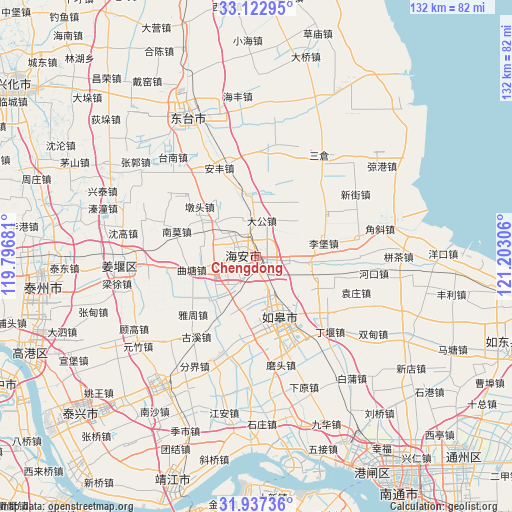
Chengdong GPS coordinates[2]
32° 31' 55.596" North, 120° 29' 59.748" East
| Map corner | latitude | longitude |
|---|---|---|
| Upper-left | 33.12295°, | 119.79681° |
| Center: | 32.53211°, | 120.49993° |
| Lower-right: | 31.93736°, | 121.20306° |
| Map W x H: | 131.8×131.8 km | = 81.9×81.9mi |
| max Lat: | 53.31946° ⇑35.8% North |
| Chengdong: | 32.53211° |
| min Lat: | ⇓64.2% South 18.22056° |
| min Long | Chengdong | max Long |
| 75.07348° | 120.49993° | 134.28917° |
| W 85.1%⇐ | ⇒14.9% E |
Elevation
Elevation of Chengdong is 5 m = 16 ft, and this is 479.8 m = 1574 ft below average elevation for this country.
| Max E: |
5622 m = 18445 ft | 97.2% |
| Avg. | 484.8 m = 1591 ft | |
| Chengdong | 5 m = 16 ft | |
Min E: |
-3 m = -10 ft | 2.8% |
See also: China elevation on elevation.city.
Geographical zone
Chengdong is located in North temperate zone (between Tropic of Cancer and the Arctic Circle). Distance of this Northern Tropic circle is 1011.3 km =628.4 mi to South.| Distance of | km | miles | from Chengdong |
|---|---|---|---|
| North Pole | 6389.8 | 3970.4 | to North |
| Arctic Circle | 3783.9 | 2351.2 | to North |
| Tropic Cancer | 1011.3 | 628.4 | to South |
| Equator | 3617.2 | 2247.6 | to South |


Nearby cities:
15 places around Chengdong: (largest is in red/bold)
• Chaiwan
9.1 km =5.7 mi,  155°
155°
• Chaoqiao
16.4 km =10.2 mi,  82°
82°
• Dagong
9.4 km =5.8 mi,  10°
10°
• Dongchen
19.6 km =12.2 mi,  137°
137°
• Duntou
19.1 km =11.9 mi,  311°
311°
• Fu’an
16.4 km =10.2 mi,  351°
351°
• Hai’an
4.9 km =3 mi,  285°
285°
• Huji
11.1 km =6.9 mi,  261°
261°
• Libao
17.6 km =10.9 mi, 78°
• Qutang
16.7 km =10.4 mi, 256°
• Rucheng
16.8 km =10.4 mi, 162°
• Sunzhuang
14.5 km =9 mi,  224°
224°
• Xichang
8.6 km =5.3 mi,  95°
95°
• Xue’an
19.6 km =12.2 mi,  114°
114°
• Yuanqiao
18.5 km =11.5 mi,  187°
187°
Sources, notices
• [Note1] Compared only with cities in China existing in our database
• [Src1] Map data: © OpenStreetMap contributors (CC-BY-SA)
• [Src2] Other city data from geonames.org with taken over terms of usage.
• [Src3] Geographical zone / Annual Mean Temperature by Robert A. Rohde @ Wikipedia
