Lianzhou geodata
Lianzhou (Guangxi) is a seat of a third-order administrative division; located in China in Asia/Shanghai (GMT+8) time zone. With population of 71,423 people, there are 599 cities with bigger population in this country. Compared to other cities in China, 97.8% of cities are located further ↑North; 75.4% of cities are located further →East and 86.2% of cities have higher elevation than Lianzhou. Note1


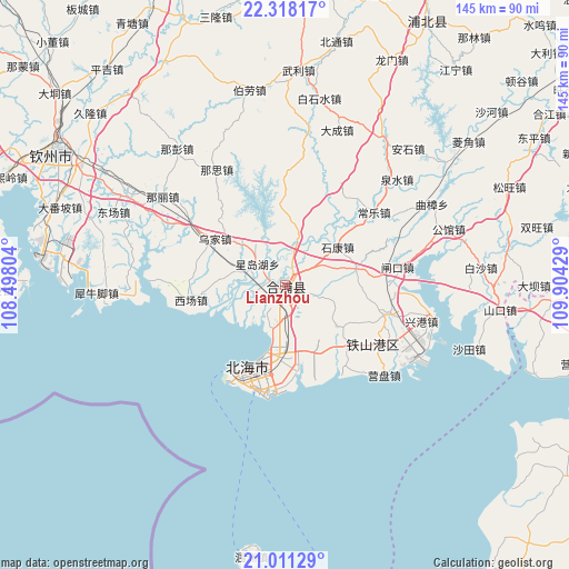
Lianzhou GPS coordinates[2]
21° 39' 58.356" North, 109° 12' 4.176" East
| Map corner | latitude | longitude |
|---|---|---|
| Upper-left | 22.31817°, | 108.49804° |
| Center: | 21.66621°, | 109.20116° |
| Lower-right: | 21.01129°, | 109.90429° |
| Map W x H: | 145.3×145.3 km | = 90.3×90.3mi |
| max Lat: | 53.31946° ⇑97.8% North |
| Lianzhou: | 21.66621° |
| min Lat: | ⇓2.2% South 18.22056° |
| min Long | Lianzhou | max Long |
| 75.07348° | 109.20116° | 134.28917° |
| W 24.6%⇐ | ⇒75.4% E |
Elevation
Elevation of Lianzhou is 14 m = 46 ft, and this is 470.8 m = 1545 ft below average elevation for this country.
| Max E: |
5622 m = 18445 ft | 86.2% |
| Avg. | 484.8 m = 1591 ft | |
| Lianzhou | 14 m = 46 ft | |
Min E: |
-3 m = -10 ft | 13.8% |
See also: Lianzhou elevation on elevation.city.
Geographical zone
Lianzhou is located in North Torrid zone (between Equator and Tropic of Cancer). Distance of this Northern Tropic circle is 196.9 km =122.3 mi to North.| Distance of | km | miles | from Lianzhou |
|---|---|---|---|
| North Pole | 7598 | 4721.2 | to North |
| Arctic Circle | 4992.1 | 3101.9 | to North |
| Tropic Cancer | 196.9 | 122.3 | to North |
| Equator | 2409.1 | 1496.9 | to South |


Nearby cities:
15 places around Lianzhou: (largest is in red/bold)
• Beihai
22.9 km =14.2 mi,  207°
207°
• Caotan
74.8 km =46.5 mi,  126°
126°
• Changshan
84.3 km =52.4 mi,  80°
80°
• Cheban
67.2 km =41.8 mi,  104°
104°
• Gangmen
79.7 km =49.5 mi, 129°
• Gaoqiao
58.5 km =36.4 mi, 96°
• Jiepao
84 km =52.2 mi,  110°
110°
• Lemin
82.5 km =51.3 mi,  135°
135°
• Lingcheng
84.7 km =52.6 mi,  6°
6°
• Qingping
74.3 km =46.2 mi,  93°
93°
• Qinzhou
68.5 km =42.6 mi,  299°
299°
• Shijing
85 km =52.8 mi, 87°
• Xiaojiang
76.5 km =47.5 mi,  28°
28°
• Yanggan
83.5 km =51.9 mi,  117°
117°
• Yingzai
77.4 km =48.1 mi, 104°
Sources, notices
• [Note1] Compared only with cities in China existing in our database
• [Src1] Map data: © OpenStreetMap contributors (CC-BY-SA)
• [Src2] Other city data from geonames.org with taken over terms of usage.
• [Src3] Geographical zone / Annual Mean Temperature by Robert A. Rohde @ Wikipedia
