Beihai geodata
Beihai (Guangxi) is a populated place; located in China in Asia/Shanghai (GMT+8) time zone. With population of 289,568 people, there are 182 cities with bigger population in this country. Compared to other cities in China, 98.1% of cities are located further ↑North; 75.9% of cities are located further →East and 98.9% of cities have higher elevation than Beihai. Note1


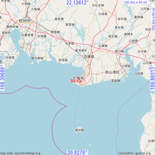
Beihai GPS coordinates[2]
21° 28' 59.988" North, 109° 6' 0" East
| Map corner | latitude | longitude |
|---|---|---|
| Upper-left | 22.13612°, | 108.39688° |
| Center: | 21.48333°, | 109.1° |
| Lower-right: | 20.8276°, | 109.80313° |
| Map W x H: | 145.5×145.5 km | = 90.4×90.4mi |
| max Lat: | 53.31946° ⇑98.1% North |
| Beihai: | 21.48333° |
| min Lat: | ⇓1.9% South 18.22056° |
| min Long | Beihai | max Long |
| 75.07348° | 109.1° | 134.28917° |
| W 24.1%⇐ | ⇒75.9% E |
Elevation
Elevation of Beihai is 3 m = 10 ft, and this is 481.8 m = 1581 ft below average elevation for this country.
| Max E: |
5622 m = 18445 ft | 98.9% |
| Avg. | 484.8 m = 1591 ft | |
| Beihai | 3 m = 10 ft | |
Min E: |
-3 m = -10 ft | 1.1% |
See also: Beihai elevation on elevation.city.
Geographical zone
Beihai is located in North Torrid zone (between Equator and Tropic of Cancer). Distance of this Northern Tropic circle is 217.2 km =135 mi to North.| Distance of | km | miles | from Beihai |
|---|---|---|---|
| North Pole | 7618.3 | 4733.8 | to North |
| Arctic Circle | 5012.5 | 3114.6 | to North |
| Tropic Cancer | 217.2 | 135 | to North |
| Equator | 2388.7 | 1484.3 | to South |


Nearby cities:
15 places around Beihai: (largest is in red/bold)
• Beipo
87.3 km =54.2 mi,  109°
109°
• Caotan
74.6 km =46.4 mi, 109°
• Cheban
75.7 km =47 mi,  87°
87°
• Gangmen
78.4 km =48.7 mi, 112°
• Gaoqiao
70.1 km =43.6 mi,  78°
78°
• Hetou
91 km =56.5 mi,  121°
121°
• Jianghong
82.3 km =51.1 mi,  129°
129°
• Jiepao
89.5 km =55.6 mi,  96°
96°
• Jijia
93.1 km =57.8 mi, 129°
• Lemin
78.3 km =48.7 mi, 119°
• Lianzhou
22.9 km =14.2 mi,  27°
27°
• Qingping
86.1 km =53.5 mi, 79°
• Qinzhou
73.2 km =45.5 mi,  318°
318°
• Yanggan
86.6 km =53.8 mi, 101°
• Yingzai
85.4 km =53.1 mi, 89°
Sources, notices
• [Note1] Compared only with cities in China existing in our database
• [Src1] Map data: © OpenStreetMap contributors (CC-BY-SA)
• [Src2] Other city data from geonames.org with taken over terms of usage.
• [Src3] Geographical zone / Annual Mean Temperature by Robert A. Rohde @ Wikipedia
