Dadeng geodata
Dadeng (Fujian) is a populated place; located in China in Asia/Shanghai (GMT+8) time zone. With population of 2,520 people, there are 984 cities with bigger population in this country. Compared to other cities in China, 88.3% of cities are located further ↑North; 72.1% of cities are located further ←West and 84.9% of cities have higher elevation than Dadeng. Note1


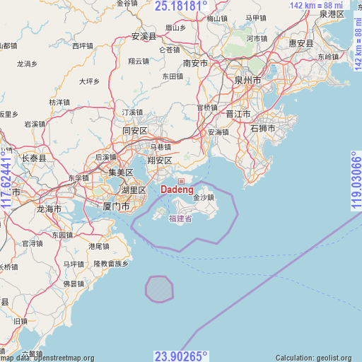
Dadeng GPS coordinates[2]
24° 32' 37.896" North, 118° 19' 39.108" East
| Map corner | latitude | longitude |
|---|---|---|
| Upper-left | 25.18181°, | 117.62441° |
| Center: | 24.54386°, | 118.32753° |
| Lower-right: | 23.90265°, | 119.03066° |
| Map W x H: | 142.2×142.2 km | = 88.4×88.4mi |
| max Lat: | 53.31946° ⇑88.3% North |
| Dadeng: | 24.54386° |
| min Lat: | ⇓11.7% South 18.22056° |
| min Long | Dadeng | max Long |
| 75.07348° | 118.32753° | 134.28917° |
| W 72.1%⇐ | ⇒27.9% E |
Elevation
Elevation of Dadeng is 16 m = 52 ft, and this is 468.8 m = 1538 ft below average elevation for this country.
| Max E: |
5622 m = 18445 ft | 84.9% |
| Avg. | 484.8 m = 1591 ft | |
| Dadeng | 16 m = 52 ft | |
Min E: |
-3 m = -10 ft | 15.1% |
See also: China elevation on elevation.city.
Geographical zone
Dadeng is located in North temperate zone (between Tropic of Cancer and the Arctic Circle). Distance of this Northern Tropic circle is 123.1 km =76.5 mi to South.| Distance of | km | miles | from Dadeng |
|---|---|---|---|
| North Pole | 7278 | 4522.3 | to North |
| Arctic Circle | 4672.2 | 2903.2 | to North |
| Tropic Cancer | 123.1 | 76.5 | to South |
| Equator | 2729 | 1695.7 | to South |


Nearby cities:
15 places around Dadeng: (largest is in red/bold)
• Anhai
24.3 km =15.1 mi,  36°
36°
• Aotoucun
10 km =6.2 mi,  268°
268°
• Dongshi
18.7 km =11.6 mi, 43°
• Hongtang
23.2 km =14.4 mi,  324°
324°
• Lianhecun
5.2 km =3.2 mi,  12°
12°
• Liuwudiancun
14.1 km =8.8 mi,  281°
281°
• Maxiang
16 km =9.9 mi,  328°
328°
• Shijing
12.9 km =8 mi,  49°
49°
• Tatou
21.7 km =13.5 mi,  67°
67°
• Wubao
23.6 km =14.7 mi,  75°
75°
• Xiamen
25.9 km =16.1 mi,  254°
254°
• Xike
23 km =14.3 mi,  308°
308°
• Xindian
11.5 km =7.1 mi, 309°
• Xinxu
22.9 km =14.2 mi,  340°
340°
• Yingcun
23.5 km =14.6 mi,  286°
286°
Sources, notices
• [Note1] Compared only with cities in China existing in our database
• [Src1] Map data: © OpenStreetMap contributors (CC-BY-SA)
• [Src2] Other city data from geonames.org with taken over terms of usage.
• [Src3] Geographical zone / Annual Mean Temperature by Robert A. Rohde @ Wikipedia
