Lianjiang geodata
Lianjiang (Guangdong) is a populated place; located in China in Asia/Urumqi (GMT+6) time zone. With population of 100,341 people, there are 423 cities with bigger population in this country. Compared to other cities in China, 97.9% of cities are located further ↑North; 70.1% of cities are located further →East and 71.6% of cities have higher elevation than Lianjiang. Note1


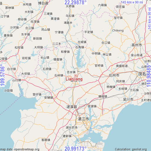
Lianjiang GPS coordinates[2]
21° 38' 48.228" North, 110° 16' 54.192" East
| Map corner | latitude | longitude |
|---|---|---|
| Upper-left | 22.29878°, | 109.5786° |
| Center: | 21.64673°, | 110.28172° |
| Lower-right: | 20.99173°, | 110.98485° |
| Map W x H: | 145.3×145.3 km | = 90.3×90.3mi |
| max Lat: | 53.31946° ⇑97.9% North |
| Lianjiang: | 21.64673° |
| min Lat: | ⇓2.1% South 18.22056° |
| min Long | Lianjiang | max Long |
| 75.07348° | 110.28172° | 134.28917° |
| W 29.9%⇐ | ⇒70.1% E |
Elevation
Elevation of Lianjiang is 46 m = 151 ft, and this is 438.8 m = 1440 ft below average elevation for this country.
| Max E: |
5622 m = 18445 ft | 71.6% |
| Avg. | 484.8 m = 1591 ft | |
| Lianjiang | 46 m = 151 ft | |
Min E: |
-3 m = -10 ft | 28.4% |
See also: Lianjiang elevation on elevation.city.
Geographical zone
Lianjiang is located in North Torrid zone (between Equator and Tropic of Cancer). Distance of this Northern Tropic circle is 199 km =123.7 mi to North.| Distance of | km | miles | from Lianjiang |
|---|---|---|---|
| North Pole | 7600.2 | 4722.5 | to North |
| Arctic Circle | 4994.3 | 3103.3 | to North |
| Tropic Cancer | 199 | 123.7 | to North |
| Equator | 2406.9 | 1495.6 | to South |


Nearby cities:
15 places around Lianjiang: (largest is in red/bold)
• Daqiao
23.8 km =14.8 mi,  110°
110°
• Guanqiao
24.1 km =15 mi,  66°
66°
• Hechun
6 km =3.7 mi,  18°
18°
• Heliao
25.2 km =15.7 mi,  338°
338°
• Jishui
4.8 km =3 mi,  307°
307°
• Liangdong
20.2 km =12.6 mi,  144°
144°
• Luozhou
4.6 km =2.9 mi,  186°
186°
• Shicheng
5.6 km =3.5 mi, 188°
• Shijiao
26 km =16.2 mi,  6°
6°
• Shiling
16 km =9.9 mi,  271°
271°
• Shiwan
26.4 km =16.4 mi,  84°
84°
• Tangpeng
24 km =14.9 mi, 313°
• Xinmin
16.2 km =10.1 mi,  213°
213°
• Xin’an
15.4 km =9.6 mi,  88°
88°
• Yatang
25.1 km =15.6 mi,  261°
261°
Sources, notices
• [Note1] Compared only with cities in China existing in our database
• [Src1] Map data: © OpenStreetMap contributors (CC-BY-SA)
• [Src2] Other city data from geonames.org with taken over terms of usage.
• [Src3] Geographical zone / Annual Mean Temperature by Robert A. Rohde @ Wikipedia
