Shiling geodata
Shiling (Guangdong) is a seat of a fourth-order administrative division; located in China in Asia/Urumqi (GMT+6) time zone. In our database, there are 1268 cities with bigger population. Compared to other cities in China, 97.8% of cities are located further ↑North; 70.6% of cities are located further →East and 72.7% of cities have higher elevation than Shiling. Note1


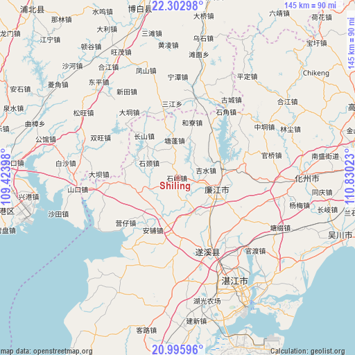
Shiling GPS coordinates[2]
21° 39' 3.42" North, 110° 7' 37.56" East
| Map corner | latitude | longitude |
|---|---|---|
| Upper-left | 22.30298°, | 109.42398° |
| Center: | 21.65095°, | 110.1271° |
| Lower-right: | 20.99596°, | 110.83023° |
| Map W x H: | 145.3×145.3 km | = 90.3×90.3mi |
| max Lat: | 53.31946° ⇑97.8% North |
| Shiling: | 21.65095° |
| min Lat: | ⇓2.2% South 18.22056° |
| min Long | Shiling | max Long |
| 75.07348° | 110.1271° | 134.28917° |
| W 29.4%⇐ | ⇒70.6% E |
Elevation
Elevation of Shiling is 43 m = 141 ft, and this is 441.8 m = 1449 ft below average elevation for this country.
| Max E: |
5622 m = 18445 ft | 72.7% |
| Avg. | 484.8 m = 1591 ft | |
| Shiling | 43 m = 141 ft | |
Min E: |
-3 m = -10 ft | 27.3% |
See also: China elevation on elevation.city.
Geographical zone
Shiling is located in North Torrid zone (between Equator and Tropic of Cancer). Distance of this Northern Tropic circle is 198.6 km =123.4 mi to North.| Distance of | km | miles | from Shiling |
|---|---|---|---|
| North Pole | 7599.7 | 4722.2 | to North |
| Arctic Circle | 4993.8 | 3103 | to North |
| Tropic Cancer | 198.6 | 123.4 | to North |
| Equator | 2407.4 | 1495.9 | to South |


Nearby cities:
15 places around Shiling: (largest is in red/bold)
• Anpu
24.2 km =15 mi,  205°
205°
• Changshan
20.5 km =12.7 mi,  322°
322°
• Hechun
18.7 km =11.6 mi,  73°
73°
• Heliao
23.8 km =14.8 mi,  15°
15°
• Hengshan
20.6 km =12.8 mi,  198°
198°
• Jishui
12.4 km =7.7 mi,  78°
78°
• Lianjiang
16 km =9.9 mi,  91°
91°
• Luozhou
16.3 km =10.1 mi,  107°
107°
• Qingping
21.7 km =13.5 mi,  262°
262°
• Shicheng
16.3 km =10.1 mi, 111°
• Shijing
12 km =7.5 mi,  296°
296°
• Tangpeng
16 km =9.9 mi,  354°
354°
• Xinmin
15.6 km =9.7 mi,  153°
153°
• Yatang
9.8 km =6.1 mi,  244°
244°
• Yingzai
27.5 km =17.1 mi,  229°
229°
Sources, notices
• [Note1] Compared only with cities in China existing in our database
• [Src1] Map data: © OpenStreetMap contributors (CC-BY-SA)
• [Src2] Other city data from geonames.org with taken over terms of usage.
• [Src3] Geographical zone / Annual Mean Temperature by Robert A. Rohde @ Wikipedia
