Leping geodata
Leping (Guangdong) is a seat of a fourth-order administrative division; located in China in Asia/Shanghai (GMT+8) time zone. In our database, there are 1268 cities with bigger population. Compared to other cities in China, 93.2% of cities are located further ↑North; 57.5% of cities are located further →East and 99.7% of cities have higher elevation than Leping. Note1


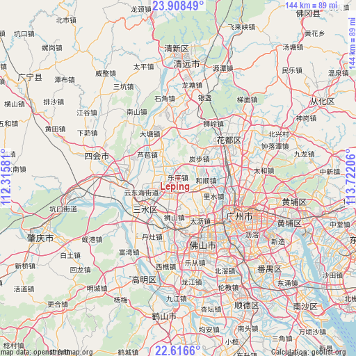
Leping GPS coordinates[2]
23° 15' 50.796" North, 113° 1' 8.148" East
| Map corner | latitude | longitude |
|---|---|---|
| Upper-left | 23.90849°, | 112.31581° |
| Center: | 23.26411°, | 113.01893° |
| Lower-right: | 22.6166°, | 113.72206° |
| Map W x H: | 143.6×143.6 km | = 89.2×89.2mi |
| max Lat: | 53.31946° ⇑93.2% North |
| Leping: | 23.26411° |
| min Lat: | ⇓6.8% South 18.22056° |
| min Long | Leping | max Long |
| 75.07348° | 113.01893° | 134.28917° |
| W 42.5%⇐ | ⇒57.5% E |
Elevation
Elevation of Leping is 1 m = 3 ft, and this is 483.8 m = 1587 ft below average elevation for this country.
| Max E: |
5622 m = 18445 ft | 99.7% |
| Avg. | 484.8 m = 1591 ft | |
| Leping | 1 m = 3 ft | |
Min E: |
-3 m = -10 ft | 0.3% |
See also: China elevation on elevation.city.
Geographical zone
Leping is located in North Torrid zone (between Equator and Tropic of Cancer). Distance of this Northern Tropic circle is 19.2 km =11.9 mi to North.| Distance of | km | miles | from Leping |
|---|---|---|---|
| North Pole | 7420.3 | 4610.8 | to North |
| Arctic Circle | 4814.4 | 2991.5 | to North |
| Tropic Cancer | 19.2 | 11.9 | to North |
| Equator | 2586.7 | 1607.3 | to South |


Nearby cities:
15 places around Leping: (largest is in red/bold)
• Chini
15.3 km =9.5 mi,  352°
352°
• Dali
18.9 km =11.7 mi,  148°
148°
• Datang
23.6 km =14.7 mi,  327°
327°
• Jianggao
21.6 km =13.4 mi,  89°
89°
• Lishui
16 km =9.9 mi,  115°
115°
• Lubao
15.9 km =9.9 mi,  308°
308°
• Luocun
23.1 km =14.4 mi,  176°
176°
• Sanshui
17.8 km =11.1 mi,  226°
226°
• Shijing
22.6 km =14 mi,  106°
106°
• Shishan
15.6 km =9.7 mi, 183°
• Tanbu
11.7 km =7.3 mi,  45°
45°
• Xinan
17.7 km =11 mi, 226°
• Xinan
22.3 km =13.9 mi,  240°
240°
• Xinhua
23.2 km =14.4 mi,  55°
55°
• Yayao
23 km =14.3 mi, 60°
Sources, notices
• [Note1] Compared only with cities in China existing in our database
• [Src1] Map data: © OpenStreetMap contributors (CC-BY-SA)
• [Src2] Other city data from geonames.org with taken over terms of usage.
• [Src3] Geographical zone / Annual Mean Temperature by Robert A. Rohde @ Wikipedia
