Sanshui geodata
Sanshui (Guangdong) is a populated place; located in China in Asia/Shanghai (GMT+8) time zone. With population of 153,714 people, there are 285 cities with bigger population in this country. Compared to other cities in China, 93.7% of cities are located further ↑North; 58.2% of cities are located further →East and 87.7% of cities have higher elevation than Sanshui. Note1


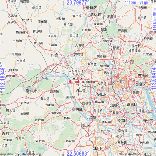
Sanshui GPS coordinates[2]
23° 9' 17.496" North, 112° 53' 29.796" East
| Map corner | latitude | longitude |
|---|---|---|
| Upper-left | 23.79977°, | 112.18849° |
| Center: | 23.15486°, | 112.89161° |
| Lower-right: | 22.50683°, | 113.59474° |
| Map W x H: | 143.8×143.8 km | = 89.4×89.4mi |
| max Lat: | 53.31946° ⇑93.7% North |
| Sanshui: | 23.15486° |
| min Lat: | ⇓6.3% South 18.22056° |
| min Long | Sanshui | max Long |
| 75.07348° | 112.89161° | 134.28917° |
| W 41.8%⇐ | ⇒58.2% E |
Elevation
Elevation of Sanshui is 12 m = 39 ft, and this is 472.8 m = 1551 ft below average elevation for this country.
| Max E: |
5622 m = 18445 ft | 87.7% |
| Avg. | 484.8 m = 1591 ft | |
| Sanshui | 12 m = 39 ft | |
Min E: |
-3 m = -10 ft | 12.3% |
See also: Sanshui elevation on elevation.city.
Geographical zone
Sanshui is located in North Torrid zone (between Equator and Tropic of Cancer). Distance of this Northern Tropic circle is 31.3 km =19.4 mi to North.| Distance of | km | miles | from Sanshui |
|---|---|---|---|
| North Pole | 7432.5 | 4618.3 | to North |
| Arctic Circle | 4826.6 | 2999.1 | to North |
| Tropic Cancer | 31.3 | 19.4 | to North |
| Equator | 2574.6 | 1599.8 | to South |


Nearby cities:
15 places around Sanshui: (largest is in red/bold)
• Baini
11.9 km =7.4 mi,  209°
209°
• Dali
23.3 km =14.5 mi,  99°
99°
• Danzao
12.7 km =7.9 mi,  169°
169°
• Dasha
18.4 km =11.4 mi,  304°
304°
• Jinli
14.4 km =8.9 mi,  234°
234°
• Leping
17.8 km =11.1 mi,  46°
46°
• Lubao
22 km =13.7 mi,  1°
1°
• Luocun
18.1 km =11.2 mi,  127°
127°
• Nanzhuang
21.8 km =13.5 mi,  148°
148°
• Shapu
21.9 km =13.6 mi,  272°
272°
• Shishan
12.5 km =7.8 mi,  106°
106°
• Xinan
0.2 km =0.1 mi, 103°
• Xinan
6.6 km =4.1 mi,  281°
281°
• Yong’an
20.9 km =13 mi, 277°
• Zhangcha
23 km =14.3 mi,  124°
124°
Sources, notices
• [Note1] Compared only with cities in China existing in our database
• [Src1] Map data: © OpenStreetMap contributors (CC-BY-SA)
• [Src2] Other city data from geonames.org with taken over terms of usage.
• [Src3] Geographical zone / Annual Mean Temperature by Robert A. Rohde @ Wikipedia
