Laiyuan geodata
Laiyuan (Fujian) is a seat of a fourth-order administrative division; located in China in Asia/Shanghai (GMT+8) time zone. In our database, there are 1268 cities with bigger population. Compared to other cities in China, 84% of cities are located further ↑North; 66.1% of cities are located further ←West and 83.7% of cities have lower elevation than Laiyuan. Note1


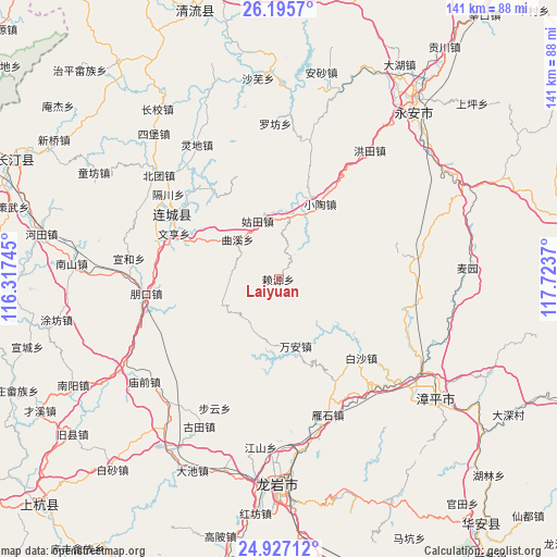
Laiyuan GPS coordinates[2]
25° 33' 47.124" North, 117° 1' 14.052" East
| Map corner | latitude | longitude |
|---|---|---|
| Upper-left | 26.1957°, | 116.31745° |
| Center: | 25.56309°, | 117.02057° |
| Lower-right: | 24.92712°, | 117.7237° |
| Map W x H: | 141.1×141.1 km | = 87.7×87.7mi |
| max Lat: | 53.31946° ⇑84% North |
| Laiyuan: | 25.56309° |
| min Lat: | ⇓16% South 18.22056° |
| min Long | Laiyuan | max Long |
| 75.07348° | 117.02057° | 134.28917° |
| W 66.1%⇐ | ⇒33.9% E |
Elevation
Elevation of Laiyuan is 895 m = 2936 ft, and this is 410.2 m = 1346 ft above average elevation for this country.
| Max E: |
5622 m = 18445 ft | 16.3% |
| Laiyuan | 895 m 2936 ft | |
| Avg. | 484.8 m = 1591 ft | |
Min E: |
-3 m = -10 ft | 83.7% |
See also: China elevation on elevation.city.
Geographical zone
Laiyuan is located in North temperate zone (between Tropic of Cancer and the Arctic Circle). Distance of this Northern Tropic circle is 236.4 km =146.9 mi to South.| Distance of | km | miles | from Laiyuan |
|---|---|---|---|
| North Pole | 7164.7 | 4451.9 | to North |
| Arctic Circle | 4558.8 | 2832.7 | to North |
| Tropic Cancer | 236.4 | 146.9 | to South |
| Equator | 2842.3 | 1766.1 | to South |


Nearby cities:
15 places around Laiyuan: (largest is in red/bold)
• Baisha
27.8 km =17.3 mi,  132°
132°
• Chishui
27.3 km =17 mi,  81°
81°
• Gechuan
35.4 km =22 mi,  307°
307°
• Gutian
15.7 km =9.8 mi,  339°
339°
• Jiele
30.1 km =18.7 mi, 307°
• Juxi
29.3 km =18.2 mi,  254°
254°
• Lianfeng
33.8 km =21 mi,  297°
297°
• Liwu
17.9 km =11.1 mi, 302°
• Pengkou
33.9 km =21.1 mi,  263°
263°
• Quxi
14.6 km =9.1 mi, 313°
• Shuangyang
34.4 km =21.4 mi, 81°
• Wan’an
17.6 km =10.9 mi,  167°
167°
• Wenheng
29.1 km =18.1 mi,  293°
293°
• Xiaotao
21.3 km =13.2 mi,  28°
28°
• Yanshi
36.2 km =22.5 mi,  160°
160°
Sources, notices
• [Note1] Compared only with cities in China existing in our database
• [Src1] Map data: © OpenStreetMap contributors (CC-BY-SA)
• [Src2] Other city data from geonames.org with taken over terms of usage.
• [Src3] Geographical zone / Annual Mean Temperature by Robert A. Rohde @ Wikipedia
