Kuitan geodata
Kuitan (Guangdong) is a seat of a fourth-order administrative division; located in China in Asia/Shanghai (GMT+8) time zone. In our database, there are 1268 cities with bigger population. Compared to other cities in China, 94.1% of cities are located further ↑North; 60% of cities are located further ←West and 82.9% of cities have higher elevation than Kuitan. Note1


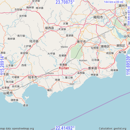
Kuitan GPS coordinates[2]
23° 3' 48.204" North, 115° 59' 32.136" East
| Map corner | latitude | longitude |
|---|---|---|
| Upper-left | 23.70875°, | 115.28914° |
| Center: | 23.06339°, | 115.99226° |
| Lower-right: | 22.41492°, | 116.69539° |
| Map W x H: | 143.9×143.9 km | = 89.4×89.4mi |
| max Lat: | 53.31946° ⇑94.1% North |
| Kuitan: | 23.06339° |
| min Lat: | ⇓5.9% South 18.22056° |
| min Long | Kuitan | max Long |
| 75.07348° | 115.99226° | 134.28917° |
| W 60%⇐ | ⇒40% E |
Elevation
Elevation of Kuitan is 20 m = 66 ft, and this is 464.8 m = 1525 ft below average elevation for this country.
| Max E: |
5622 m = 18445 ft | 82.9% |
| Avg. | 484.8 m = 1591 ft | |
| Kuitan | 20 m = 66 ft | |
Min E: |
-3 m = -10 ft | 17.1% |
See also: China elevation on elevation.city.
Geographical zone
Kuitan is located in North Torrid zone (between Equator and Tropic of Cancer). Distance of this Northern Tropic circle is 41.5 km =25.8 mi to North.| Distance of | km | miles | from Kuitan |
|---|---|---|---|
| North Pole | 7442.7 | 4624.7 | to North |
| Arctic Circle | 4836.8 | 3005.4 | to North |
| Tropic Cancer | 41.5 | 25.8 | to North |
| Equator | 2564.4 | 1593.4 | to South |


Nearby cities:
15 places around Kuitan: (largest is in red/bold)
• Aojiang
15 km =9.3 mi,  157°
157°
• Beiyang
15.3 km =9.5 mi,  256°
256°
• Chuanpu
20.8 km =12.9 mi,  329°
329°
• Daping
19.6 km =12.2 mi,  311°
311°
• Donggang
10.3 km =6.4 mi,  214°
214°
• Gaopu
10.7 km =6.6 mi,  345°
345°
• Jiadong
24.5 km =15.2 mi,  148°
148°
• Jiazi
22.1 km =13.7 mi, 157°
• Longjiang
22.1 km =13.7 mi,  112°
112°
• Meilin
19.6 km =12.2 mi,  1°
1°
• Nantang
18.8 km =11.7 mi, 205°
• Neihu
19.6 km =12.2 mi,  241°
241°
• Qishi
22.1 km =13.7 mi,  138°
138°
• Xixi
21 km =13 mi,  117°
117°
• Yunluo
21.8 km =13.5 mi,  22°
22°
Sources, notices
• [Note1] Compared only with cities in China existing in our database
• [Src1] Map data: © OpenStreetMap contributors (CC-BY-SA)
• [Src2] Other city data from geonames.org with taken over terms of usage.
• [Src3] Geographical zone / Annual Mean Temperature by Robert A. Rohde @ Wikipedia
