Chuanpu geodata
Chuanpu (Guangdong) is a seat of a fourth-order administrative division; located in China in Asia/Shanghai (GMT+8) time zone. In our database, there are 1268 cities with bigger population. Compared to other cities in China, 93.4% of cities are located further ↑North; 59.4% of cities are located further ←West and 64.9% of cities have higher elevation than Chuanpu. Note1


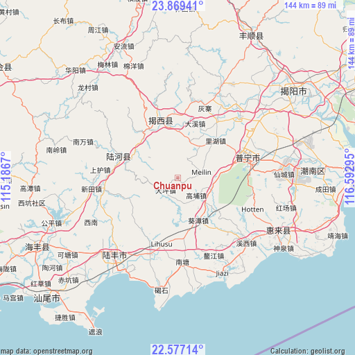
Chuanpu GPS coordinates[2]
23° 13' 29.424" North, 115° 53' 23.352" East
| Map corner | latitude | longitude |
|---|---|---|
| Upper-left | 23.86941°, | 115.1867° |
| Center: | 23.22484°, | 115.88982° |
| Lower-right: | 22.57714°, | 116.59295° |
| Map W x H: | 143.7×143.7 km | = 89.3×89.3mi |
| max Lat: | 53.31946° ⇑93.4% North |
| Chuanpu: | 23.22484° |
| min Lat: | ⇓6.6% South 18.22056° |
| min Long | Chuanpu | max Long |
| 75.07348° | 115.88982° | 134.28917° |
| W 59.4%⇐ | ⇒40.6% E |
Elevation
Elevation of Chuanpu is 73 m = 240 ft, and this is 411.8 m = 1351 ft below average elevation for this country.
| Max E: |
5622 m = 18445 ft | 64.9% |
| Avg. | 484.8 m = 1591 ft | |
| Chuanpu | 73 m = 240 ft | |
Min E: |
-3 m = -10 ft | 35.1% |
See also: China elevation on elevation.city.
Geographical zone
Chuanpu is located in North Torrid zone (between Equator and Tropic of Cancer). Distance of this Northern Tropic circle is 23.6 km =14.7 mi to North.| Distance of | km | miles | from Chuanpu |
|---|---|---|---|
| North Pole | 7424.7 | 4613.5 | to North |
| Arctic Circle | 4818.8 | 2994.3 | to North |
| Tropic Cancer | 23.6 | 14.7 | to North |
| Equator | 2582.4 | 1604.6 | to South |


Nearby cities:
15 places around Chuanpu: (largest is in red/bold)
• Beiyang
22.1 km =13.7 mi,  191°
191°
• Daping
6.7 km =4.2 mi,  219°
219°
• Daxi
23.1 km =14.4 mi,  17°
17°
• Dongkeng
19.1 km =11.9 mi,  287°
287°
• Gaopu
10.9 km =6.8 mi,  134°
134°
• Hepo
23.7 km =14.7 mi,  345°
345°
• Kuitan
20.8 km =12.9 mi,  149°
149°
• Lihu
21.6 km =13.4 mi,  45°
45°
• Meilin
11 km =6.8 mi,  81°
81°
• Meitang
24 km =14.9 mi,  55°
55°
• Pingshang
19.7 km =12.2 mi,  0°
0°
• Qiankeng
21 km =13 mi,  30°
30°
• Shuichun
18.5 km =11.5 mi,  302°
302°
• Wuyun
22.1 km =13.7 mi,  329°
329°
• Yunluo
19.1 km =11.9 mi, 83°
Sources, notices
• [Note1] Compared only with cities in China existing in our database
• [Src1] Map data: © OpenStreetMap contributors (CC-BY-SA)
• [Src2] Other city data from geonames.org with taken over terms of usage.
• [Src3] Geographical zone / Annual Mean Temperature by Robert A. Rohde @ Wikipedia
