Jiazi geodata
Jiazi (Guangdong) is a seat of a fourth-order administrative division; located in China in Asia/Shanghai (GMT+8) time zone. With population of 130,298 people, there are 337 cities with bigger population in this country. Compared to other cities in China, 95% of cities are located further ↑North; 60.5% of cities are located further ←West and 94.3% of cities have higher elevation than Jiazi. Note1


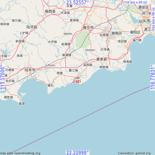
Jiazi GPS coordinates[2]
22° 52' 45.552" North, 116° 4' 23.448" East
| Map corner | latitude | longitude |
|---|---|---|
| Upper-left | 23.52557°, | 115.37006° |
| Center: | 22.87932°, | 116.07318° |
| Lower-right: | 22.22998°, | 116.77631° |
| Map W x H: | 144.1×144.1 km | = 89.5×89.5mi |
| max Lat: | 53.31946° ⇑95% North |
| Jiazi: | 22.87932° |
| min Lat: | ⇓5% South 18.22056° |
| min Long | Jiazi | max Long |
| 75.07348° | 116.07318° | 134.28917° |
| W 60.5%⇐ | ⇒39.5% E |
Elevation
Elevation of Jiazi is 7 m = 23 ft, and this is 477.8 m = 1568 ft below average elevation for this country.
| Max E: |
5622 m = 18445 ft | 94.3% |
| Avg. | 484.8 m = 1591 ft | |
| Jiazi | 7 m = 23 ft | |
Min E: |
-3 m = -10 ft | 5.7% |
See also: Jiazi elevation on elevation.city.
Geographical zone
Jiazi is located in North Torrid zone (between Equator and Tropic of Cancer). Distance of this Northern Tropic circle is 62 km =38.5 mi to North.| Distance of | km | miles | from Jiazi |
|---|---|---|---|
| North Pole | 7463.1 | 4637.4 | to North |
| Arctic Circle | 4857.2 | 3018.1 | to North |
| Tropic Cancer | 62 | 38.5 | to North |
| Equator | 2543.9 | 1580.7 | to South |


Nearby cities:
15 places around Jiazi: (largest is in red/bold)
• Aojiang
7 km =4.3 mi,  338°
338°
• Donggang
18.6 km =11.6 mi,  310°
310°
• Donglong
25.9 km =16.1 mi,  56°
56°
• Hudong
14.3 km =8.9 mi,  241°
241°
• Huicheng
28.4 km =17.6 mi,  51°
51°
• Jiadong
4.5 km =2.8 mi,  95°
95°
• Jieshi
26 km =16.2 mi,  252°
252°
• Kuitan
22.1 km =13.7 mi, 337°
• Longjiang
17.2 km =10.7 mi, 45°
• Nantang
16.7 km =10.4 mi,  282°
282°
• Neihu
27.8 km =17.3 mi,  293°
293°
• Qiaochong
28.6 km =17.8 mi, 279°
• Qishi
7.6 km =4.7 mi, 57°
• Shenquan
26.9 km =16.7 mi,  67°
67°
• Xixi
15 km =9.3 mi,  43°
43°
Sources, notices
• [Note1] Compared only with cities in China existing in our database
• [Src1] Map data: © OpenStreetMap contributors (CC-BY-SA)
• [Src2] Other city data from geonames.org with taken over terms of usage.
• [Src3] Geographical zone / Annual Mean Temperature by Robert A. Rohde @ Wikipedia
