Kengdi geodata
Kengdi (Fujian) is a seat of a fourth-order administrative division; located in China in Asia/Shanghai (GMT+8) time zone. In our database, there are 1268 cities with bigger population. Compared to other cities in China, 76.3% of cities are located further ↑North; 78.9% of cities are located further ←West and 83.2% of cities have lower elevation than Kengdi. Note1


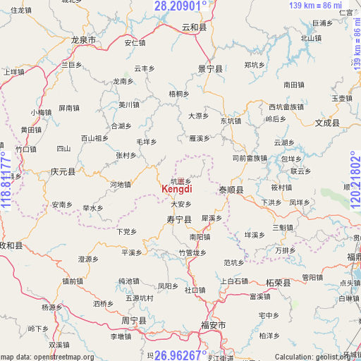
Kengdi GPS coordinates[2]
27° 35' 15.396" North, 119° 30' 53.604" East
| Map corner | latitude | longitude |
|---|---|---|
| Upper-left | 28.20901°, | 118.81177° |
| Center: | 27.58761°, | 119.51489° |
| Lower-right: | 26.96267°, | 120.21802° |
| Map W x H: | 138.6×138.6 km | = 86.1×86.1mi |
| max Lat: | 53.31946° ⇑76.3% North |
| Kengdi: | 27.58761° |
| min Lat: | ⇓23.7% South 18.22056° |
| min Long | Kengdi | max Long |
| 75.07348° | 119.51489° | 134.28917° |
| W 78.9%⇐ | ⇒21.1% E |
Elevation
Elevation of Kengdi is 863 m = 2831 ft, and this is 378.2 m = 1241 ft above average elevation for this country.
| Max E: |
5622 m = 18445 ft | 16.8% |
| Kengdi | 863 m 2831 ft | |
| Avg. | 484.8 m = 1591 ft | |
Min E: |
-3 m = -10 ft | 83.2% |
See also: China elevation on elevation.city.
Geographical zone
Kengdi is located in North temperate zone (between Tropic of Cancer and the Arctic Circle). Distance of this Northern Tropic circle is 461.5 km =286.8 mi to South.| Distance of | km | miles | from Kengdi |
|---|---|---|---|
| North Pole | 6939.6 | 4312.1 | to North |
| Arctic Circle | 4333.7 | 2692.8 | to North |
| Tropic Cancer | 461.5 | 286.8 | to South |
| Equator | 3067.5 | 1906.1 | to South |


Nearby cities:
15 places around Kengdi: (largest is in red/bold)
• Aoyang
14.4 km =8.9 mi,  185°
185°
• Beipai
20.2 km =12.6 mi,  69°
69°
• Dadi
20.5 km =12.7 mi,  344°
344°
• Da’an
8.6 km =5.3 mi,  177°
177°
• Guantang
11.7 km =7.3 mi,  326°
326°
• Jiadi
14.6 km =9.1 mi,  2°
2°
• Jianggen
8.4 km =5.2 mi,  246°
246°
• Lingbei
14.4 km =8.9 mi,  85°
85°
• Luoyang
19.6 km =12.2 mi,  98°
98°
• Maoyang
20 km =12.4 mi,  319°
319°
• Qingyuan
20.8 km =12.9 mi, 186°
• Qiulu
22.7 km =14.1 mi,  312°
312°
• Tuoxi
21.8 km =13.5 mi,  222°
222°
• Yanxi
18.2 km =11.3 mi,  25°
25°
• Zuoxi
14.2 km =8.8 mi,  289°
289°
Sources, notices
• [Note1] Compared only with cities in China existing in our database
• [Src1] Map data: © OpenStreetMap contributors (CC-BY-SA)
• [Src2] Other city data from geonames.org with taken over terms of usage.
• [Src3] Geographical zone / Annual Mean Temperature by Robert A. Rohde @ Wikipedia
