Lingbei geodata
Lingbei (Zhejiang) is a seat of a fourth-order administrative division; located in China in Asia/Shanghai (GMT+8) time zone. In our database, there are 1268 cities with bigger population. Compared to other cities in China, 76.2% of cities are located further ↑North; 79.8% of cities are located further ←West and 76.1% of cities have lower elevation than Lingbei. Note1


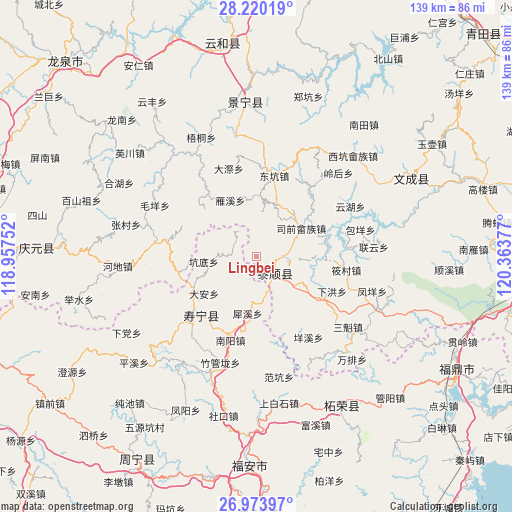
Lingbei GPS coordinates[2]
27° 35' 55.86" North, 119° 39' 38.304" East
| Map corner | latitude | longitude |
|---|---|---|
| Upper-left | 28.22019°, | 118.95752° |
| Center: | 27.59885°, | 119.66064° |
| Lower-right: | 26.97397°, | 120.36377° |
| Map W x H: | 138.6×138.6 km | = 86.1×86.1mi |
| max Lat: | 53.31946° ⇑76.2% North |
| Lingbei: | 27.59885° |
| min Lat: | ⇓23.8% South 18.22056° |
| min Long | Lingbei | max Long |
| 75.07348° | 119.66064° | 134.28917° |
| W 79.8%⇐ | ⇒20.2% E |
Elevation
Elevation of Lingbei is 550 m = 1804 ft, and this is 65.2 m = 214 ft above average elevation for this country.
| Max E: |
5622 m = 18445 ft | 23.9% |
| Lingbei | 550 m 1804 ft | |
| Avg. | 484.8 m = 1591 ft | |
Min E: |
-3 m = -10 ft | 76.1% |
See also: China elevation on elevation.city.
Geographical zone
Lingbei is located in North temperate zone (between Tropic of Cancer and the Arctic Circle). Distance of this Northern Tropic circle is 462.8 km =287.6 mi to South.| Distance of | km | miles | from Lingbei |
|---|---|---|---|
| North Pole | 6938.4 | 4311.3 | to North |
| Arctic Circle | 4332.5 | 2692.1 | to North |
| Tropic Cancer | 462.8 | 287.6 | to South |
| Equator | 3068.7 | 1906.8 | to South |


Nearby cities:
15 places around Lingbei: (largest is in red/bold)
• Aoyang
22.1 km =13.7 mi,  225°
225°
• Baizhang
19.7 km =12.2 mi,  71°
71°
• Beipai
7.4 km =4.6 mi,  38°
38°
• Da’an
17.1 km =10.6 mi, 234°
• Dongkeng
22.5 km =14 mi,  12°
12°
• Jiadi
19.1 km =11.9 mi,  314°
314°
• Jingnan
18.1 km =11.2 mi,  354°
354°
• Kengdi
14.4 km =8.9 mi,  265°
265°
• Luoyang
6.5 km =4 mi,  129°
129°
• Nanyuan
17.8 km =11.1 mi,  139°
139°
• Siqian
14.5 km =9 mi,  57°
57°
• Xianren
9.2 km =5.7 mi,  96°
96°
• Yanxi
16.5 km =10.3 mi,  337°
337°
• Zhouling
20.1 km =12.5 mi,  157°
157°
• Zhuli
16.1 km =10 mi, 41°
Sources, notices
• [Note1] Compared only with cities in China existing in our database
• [Src1] Map data: © OpenStreetMap contributors (CC-BY-SA)
• [Src2] Other city data from geonames.org with taken over terms of usage.
• [Src3] Geographical zone / Annual Mean Temperature by Robert A. Rohde @ Wikipedia
