Beipai geodata
Beipai (Zhejiang) is a seat of a fourth-order administrative division; located in China in Asia/Shanghai (GMT+8) time zone. In our database, there are 1268 cities with bigger population. Compared to other cities in China, 76% of cities are located further ↑North; 80% of cities are located further ←West and 84.6% of cities have lower elevation than Beipai. Note1


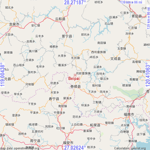
Beipai GPS coordinates[2]
27° 39' 2.988" North, 119° 42' 27" East
| Map corner | latitude | longitude |
|---|---|---|
| Upper-left | 28.27187°, | 119.00438° |
| Center: | 27.65083°, | 119.7075° |
| Lower-right: | 27.02624°, | 120.41063° |
| Map W x H: | 138.5×138.5 km | = 86.1×86.1mi |
| max Lat: | 53.31946° ⇑76% North |
| Beipai: | 27.65083° |
| min Lat: | ⇓24% South 18.22056° |
| min Long | Beipai | max Long |
| 75.07348° | 119.7075° | 134.28917° |
| W 80%⇐ | ⇒20% E |
Elevation
Elevation of Beipai is 956 m = 3136 ft, and this is 471.2 m = 1546 ft above average elevation for this country.
| Max E: |
5622 m = 18445 ft | 15.4% |
| Beipai | 956 m 3136 ft | |
| Avg. | 484.8 m = 1591 ft | |
Min E: |
-3 m = -10 ft | 84.6% |
See also: China elevation on elevation.city.
Geographical zone
Beipai is located in North temperate zone (between Tropic of Cancer and the Arctic Circle). Distance of this Northern Tropic circle is 468.6 km =291.2 mi to South.| Distance of | km | miles | from Beipai |
|---|---|---|---|
| North Pole | 6932.6 | 4307.7 | to North |
| Arctic Circle | 4326.7 | 2688.5 | to North |
| Tropic Cancer | 468.6 | 291.2 | to South |
| Equator | 3074.5 | 1910.4 | to South |


Nearby cities:
15 places around Beipai: (largest is in red/bold)
• Baizhang
14.1 km =8.8 mi,  88°
88°
• Daji
21.8 km =13.5 mi,  326°
326°
• Dongkeng
16.2 km =10.1 mi,  1°
1°
• Fengmen
15.8 km =9.8 mi,  70°
70°
• Huangqiao
16.8 km =10.4 mi,  31°
31°
• Jiadi
19.8 km =12.3 mi,  292°
292°
• Jingnan
13.8 km =8.6 mi, 333°
• Kengdi
20.2 km =12.6 mi,  249°
249°
• Lingbei
7.4 km =4.6 mi,  218°
218°
• Luoyang
10 km =6.2 mi,  177°
177°
• Nanyuan
20.5 km =12.7 mi,  160°
160°
• Siqian
7.8 km =4.8 mi,  75°
75°
• Xianren
8.2 km =5.1 mi,  146°
146°
• Yanxi
14.5 km =9 mi,  310°
310°
• Zhuli
8.8 km =5.5 mi,  43°
43°
Sources, notices
• [Note1] Compared only with cities in China existing in our database
• [Src1] Map data: © OpenStreetMap contributors (CC-BY-SA)
• [Src2] Other city data from geonames.org with taken over terms of usage.
• [Src3] Geographical zone / Annual Mean Temperature by Robert A. Rohde @ Wikipedia
