Jianshe geodata
Jianshe (Fujian) is a seat of a fourth-order administrative division; located in China in Asia/Shanghai (GMT+8) time zone. In our database, there are 1268 cities with bigger population. Compared to other cities in China, 82.4% of cities are located further ↑North; 69.8% of cities are located further ←West and 74.1% of cities have lower elevation than Jianshe. Note1


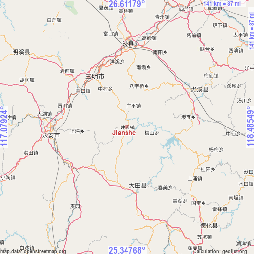
Jianshe GPS coordinates[2]
25° 58' 53.148" North, 117° 46' 56.496" East
| Map corner | latitude | longitude |
|---|---|---|
| Upper-left | 26.61179°, | 117.07924° |
| Center: | 25.98143°, | 117.78236° |
| Lower-right: | 25.34768°, | 118.48549° |
| Map W x H: | 140.6×140.6 km | = 87.4×87.4mi |
| max Lat: | 53.31946° ⇑82.4% North |
| Jianshe: | 25.98143° |
| min Lat: | ⇓17.6% South 18.22056° |
| min Long | Jianshe | max Long |
| 75.07348° | 117.78236° | 134.28917° |
| W 69.8%⇐ | ⇒30.2% E |
Elevation
Elevation of Jianshe is 503 m = 1650 ft, and this is 18.2 m = 60 ft above average elevation for this country.
| Max E: |
5622 m = 18445 ft | 25.9% |
| Jianshe | 503 m 1650 ft | |
| Avg. | 484.8 m = 1591 ft | |
Min E: |
-3 m = -10 ft | 74.1% |
See also: China elevation on elevation.city.
Geographical zone
Jianshe is located in North temperate zone (between Tropic of Cancer and the Arctic Circle). Distance of this Northern Tropic circle is 282.9 km =175.8 mi to South.| Distance of | km | miles | from Jianshe |
|---|---|---|---|
| North Pole | 7118.2 | 4423 | to North |
| Arctic Circle | 4512.3 | 2803.8 | to North |
| Tropic Cancer | 282.9 | 175.8 | to South |
| Equator | 2888.9 | 1795.1 | to South |


Nearby cities:
15 places around Jianshe: (largest is in red/bold)
• Baziqiao
23.9 km =14.9 mi,  16°
16°
• Guangping
12.7 km =7.9 mi, 16°
• Guanqian
28.4 km =17.6 mi,  39°
39°
• Huainan
5.4 km =3.4 mi,  279°
279°
• Humei
25.7 km =16 mi,  143°
143°
• Huyuan
16.5 km =10.3 mi,  355°
355°
• Meishan
13.8 km =8.6 mi,  101°
101°
• Qianping
17.2 km =10.7 mi,  151°
151°
• Qitao
11.7 km =7.3 mi,  47°
47°
• Shangping
27.6 km =17.1 mi,  265°
265°
• Taihua
19.6 km =12.2 mi,  199°
199°
• Taoyuan
29.9 km =18.6 mi,  223°
223°
• Wenjiang
8.5 km =5.3 mi,  83°
83°
• Xinyang
18 km =11.2 mi,  64°
64°
• Zhongcun
24.7 km =15.3 mi,  330°
330°
Sources, notices
• [Note1] Compared only with cities in China existing in our database
• [Src1] Map data: © OpenStreetMap contributors (CC-BY-SA)
• [Src2] Other city data from geonames.org with taken over terms of usage.
• [Src3] Geographical zone / Annual Mean Temperature by Robert A. Rohde @ Wikipedia
