Zhongcun geodata
Zhongcun (Fujian) is a seat of a fourth-order administrative division; located in China in Asia/Shanghai (GMT+8) time zone. In our database, there are 1268 cities with bigger population. Compared to other cities in China, 81.6% of cities are located further ↑North; 69.3% of cities are located further ←West and 67.5% of cities have lower elevation than Zhongcun. Note1


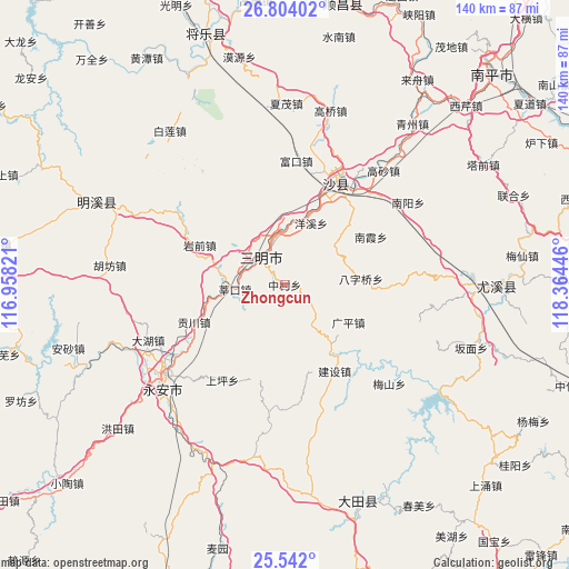
Zhongcun GPS coordinates[2]
26° 10' 28.992" North, 117° 39' 40.788" East
| Map corner | latitude | longitude |
|---|---|---|
| Upper-left | 26.80402°, | 116.95821° |
| Center: | 26.17472°, | 117.66133° |
| Lower-right: | 25.542°, | 118.36446° |
| Map W x H: | 140.3×140.3 km | = 87.2×87.2mi |
| max Lat: | 53.31946° ⇑81.6% North |
| Zhongcun: | 26.17472° |
| min Lat: | ⇓18.4% South 18.22056° |
| min Long | Zhongcun | max Long |
| 75.07348° | 117.66133° | 134.28917° |
| W 69.3%⇐ | ⇒30.7% E |
Elevation
Elevation of Zhongcun is 367 m = 1204 ft, and this is 117.8 m = 386 ft below average elevation for this country.
| Max E: |
5622 m = 18445 ft | 32.5% |
| Avg. | 484.8 m = 1591 ft | |
| Zhongcun | 367 m = 1204 ft | |
Min E: |
-3 m = -10 ft | 67.5% |
See also: China elevation on elevation.city.
Geographical zone
Zhongcun is located in North temperate zone (between Tropic of Cancer and the Arctic Circle). Distance of this Northern Tropic circle is 304.4 km =189.1 mi to South.| Distance of | km | miles | from Zhongcun |
|---|---|---|---|
| North Pole | 7096.7 | 4409.7 | to North |
| Arctic Circle | 4490.8 | 2790.5 | to North |
| Tropic Cancer | 304.4 | 189.1 | to South |
| Equator | 2910.4 | 1808.4 | to South |


Nearby cities:
15 places around Zhongcun: (largest is in red/bold)
• Baziqiao
18.9 km =11.7 mi,  85°
85°
• Chenda
15.6 km =9.7 mi,  353°
353°
• Chengdong
8.9 km =5.5 mi,  331°
331°
• Daluo
15.3 km =9.5 mi,  56°
56°
• Gongchuan
24.2 km =15 mi,  247°
247°
• Guangping
18.3 km =11.4 mi,  120°
120°
• Huainan
21.7 km =13.5 mi,  161°
161°
• Huyuan
11.9 km =7.4 mi,  114°
114°
• Jingxi
11.8 km =7.3 mi,  280°
280°
• Nanxia
24.3 km =15.1 mi, 60°
• Sanming
9.3 km =5.8 mi, 332°
• Shenkou
12.5 km =7.8 mi,  264°
264°
• Xubi
12 km =7.5 mi, 346°
• Yangxi
16.5 km =10.3 mi,  23°
23°
• Yanqian
23.1 km =14.4 mi,  295°
295°
Sources, notices
• [Note1] Compared only with cities in China existing in our database
• [Src1] Map data: © OpenStreetMap contributors (CC-BY-SA)
• [Src2] Other city data from geonames.org with taken over terms of usage.
• [Src3] Geographical zone / Annual Mean Temperature by Robert A. Rohde @ Wikipedia
