Humei geodata
Humei (Fujian) is a seat of a fourth-order administrative division; located in China in Asia/Shanghai (GMT+8) time zone. In our database, there are 1268 cities with bigger population. Compared to other cities in China, 83.2% of cities are located further ↑North; 70.3% of cities are located further ←West and 68% of cities have lower elevation than Humei. Note1


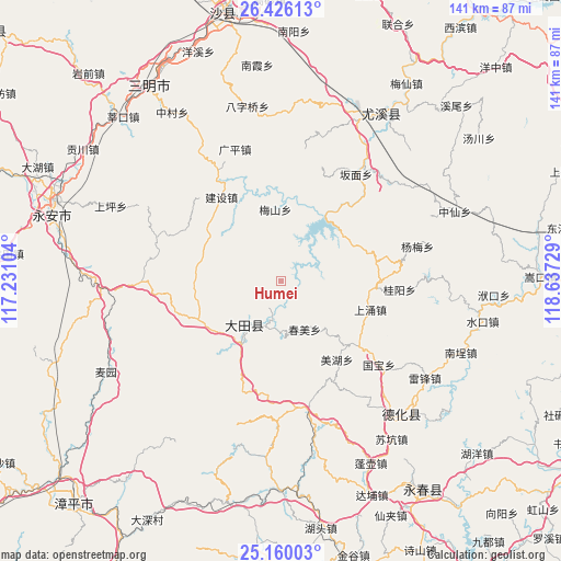
Humei GPS coordinates[2]
25° 47' 41.172" North, 117° 56' 2.976" East
| Map corner | latitude | longitude |
|---|---|---|
| Upper-left | 26.42613°, | 117.23104° |
| Center: | 25.79477°, | 117.93416° |
| Lower-right: | 25.16003°, | 118.63729° |
| Map W x H: | 140.8×140.8 km | = 87.5×87.5mi |
| max Lat: | 53.31946° ⇑83.2% North |
| Humei: | 25.79477° |
| min Lat: | ⇓16.8% South 18.22056° |
| min Long | Humei | max Long |
| 75.07348° | 117.93416° | 134.28917° |
| W 70.3%⇐ | ⇒29.7% E |
Elevation
Elevation of Humei is 376 m = 1234 ft, and this is 108.8 m = 357 ft below average elevation for this country.
| Max E: |
5622 m = 18445 ft | 32% |
| Avg. | 484.8 m = 1591 ft | |
| Humei | 376 m = 1234 ft | |
Min E: |
-3 m = -10 ft | 68% |
See also: China elevation on elevation.city.
Geographical zone
Humei is located in North temperate zone (between Tropic of Cancer and the Arctic Circle). Distance of this Northern Tropic circle is 262.2 km =162.9 mi to South.| Distance of | km | miles | from Humei |
|---|---|---|---|
| North Pole | 7139 | 4436 | to North |
| Arctic Circle | 4533.1 | 2816.7 | to North |
| Tropic Cancer | 262.2 | 162.9 | to South |
| Equator | 2868.1 | 1782.2 | to South |


Nearby cities:
15 places around Humei: (largest is in red/bold)
• Chishui
25.5 km =15.8 mi,  130°
130°
• Chunmei
13.5 km =8.4 mi,  153°
153°
• Daming
18.6 km =11.6 mi, 128°
• Huaxing
12.3 km =7.6 mi,  203°
203°
• Jianshe
25.7 km =16 mi,  323°
323°
• Junxi
14 km =8.7 mi,  219°
219°
• Meihu
24.8 km =15.4 mi,  143°
143°
• Meishan
18 km =11.2 mi,  354°
354°
• Pingshan
22.8 km =14.2 mi,  190°
190°
• Qianping
9 km =5.6 mi,  308°
308°
• Shangyong
23.3 km =14.5 mi,  106°
106°
• Shipai
18.8 km =11.7 mi,  213°
213°
• Taihua
21.8 km =13.5 mi,  275°
275°
• Tangtou
19.9 km =12.4 mi,  86°
86°
• Wenjiang
22.7 km =14.1 mi,  342°
342°
Sources, notices
• [Note1] Compared only with cities in China existing in our database
• [Src1] Map data: © OpenStreetMap contributors (CC-BY-SA)
• [Src2] Other city data from geonames.org with taken over terms of usage.
• [Src3] Geographical zone / Annual Mean Temperature by Robert A. Rohde @ Wikipedia
