Jianghua geodata
Jianghua (Jiangsu) is a seat of a fourth-order administrative division; located in China in Asia/Shanghai (GMT+8) time zone. In our database, there are 1268 cities with bigger population. Compared to other cities in China, 61.7% of cities are located further ↓South; 82% of cities are located further ←West and 97.2% of cities have higher elevation than Jianghua. Note1


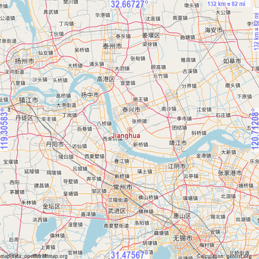
Jianghua GPS coordinates[2]
32° 4' 24.276" North, 120° 0' 32.22" East
| Map corner | latitude | longitude |
|---|---|---|
| Upper-left | 32.66727°, | 119.30583° |
| Center: | 32.07341°, | 120.00895° |
| Lower-right: | 31.47567°, | 120.71208° |
| Map W x H: | 132.5×132.5 km | = 82.3×82.3mi |
| max Lat: | 53.31946° ⇑38.3% North |
| Jianghua: | 32.07341° |
| min Lat: | ⇓61.7% South 18.22056° |
| min Long | Jianghua | max Long |
| 75.07348° | 120.00895° | 134.28917° |
| W 82%⇐ | ⇒18% E |
Elevation
Elevation of Jianghua is 5 m = 16 ft, and this is 479.8 m = 1574 ft below average elevation for this country.
| Max E: |
5622 m = 18445 ft | 97.2% |
| Avg. | 484.8 m = 1591 ft | |
| Jianghua | 5 m = 16 ft | |
Min E: |
-3 m = -10 ft | 2.8% |
See also: China elevation on elevation.city.
Geographical zone
Jianghua is located in North temperate zone (between Tropic of Cancer and the Arctic Circle). Distance of this Northern Tropic circle is 960.3 km =596.7 mi to South.| Distance of | km | miles | from Jianghua |
|---|---|---|---|
| North Pole | 6440.8 | 4002.1 | to North |
| Arctic Circle | 3834.9 | 2382.9 | to North |
| Tropic Cancer | 960.3 | 596.7 | to South |
| Equator | 3566.2 | 2215.9 | to South |


Nearby cities:
15 places around Jianghua: (largest is in red/bold)
• Baqiao
13.3 km =8.3 mi,  287°
287°
• Chunjiang
14.2 km =8.8 mi,  188°
188°
• Dasheng
8 km =5 mi,  341°
341°
• Guochuan
11.4 km =7.1 mi,  317°
317°
• Hongguang
9.2 km =5.7 mi,  97°
97°
• Jiepai
14.7 km =9.1 mi,  269°
269°
• Menghe
16.3 km =10.1 mi,  247°
247°
• Qixu
5.1 km =3.2 mi,  173°
173°
• Quxia
14.3 km =8.9 mi,  77°
77°
• Shengci
15.2 km =9.4 mi,  105°
105°
• Taixing
10.4 km =6.5 mi,  2°
2°
• Weicun
13.9 km =8.6 mi,  213°
213°
• Xilaiqiao
9.9 km =6.2 mi, 245°
• Xinqiao
9.5 km =5.9 mi,  144°
144°
• Zhangqiao
6.7 km =4.2 mi,  45°
45°
Sources, notices
• [Note1] Compared only with cities in China existing in our database
• [Src1] Map data: © OpenStreetMap contributors (CC-BY-SA)
• [Src2] Other city data from geonames.org with taken over terms of usage.
• [Src3] Geographical zone / Annual Mean Temperature by Robert A. Rohde @ Wikipedia
