Zhangqiao geodata
Zhangqiao (Jiangsu) is a seat of a fourth-order administrative division; located in China in Asia/Shanghai (GMT+8) time zone. In our database, there are 1268 cities with bigger population. Compared to other cities in China, 61.9% of cities are located further ↓South; 82.2% of cities are located further ←West and 94.3% of cities have higher elevation than Zhangqiao. Note1


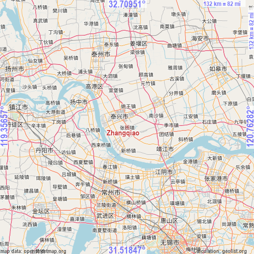
Zhangqiao GPS coordinates[2]
32° 6' 57.348" North, 120° 3' 34.884" East
| Map corner | latitude | longitude |
|---|---|---|
| Upper-left | 32.70951°, | 119.35657° |
| Center: | 32.11593°, | 120.05969° |
| Lower-right: | 31.51847°, | 120.76282° |
| Map W x H: | 132.4×132.4 km | = 82.3×82.3mi |
| max Lat: | 53.31946° ⇑38.1% North |
| Zhangqiao: | 32.11593° |
| min Lat: | ⇓61.9% South 18.22056° |
| min Long | Zhangqiao | max Long |
| 75.07348° | 120.05969° | 134.28917° |
| W 82.2%⇐ | ⇒17.8% E |
Elevation
Elevation of Zhangqiao is 7 m = 23 ft, and this is 477.8 m = 1568 ft below average elevation for this country.
| Max E: |
5622 m = 18445 ft | 94.3% |
| Avg. | 484.8 m = 1591 ft | |
| Zhangqiao | 7 m = 23 ft | |
Min E: |
-3 m = -10 ft | 5.7% |
See also: China elevation on elevation.city.
Geographical zone
Zhangqiao is located in North temperate zone (between Tropic of Cancer and the Arctic Circle). Distance of this Northern Tropic circle is 965 km =599.6 mi to South.| Distance of | km | miles | from Zhangqiao |
|---|---|---|---|
| North Pole | 6436.1 | 3999.2 | to North |
| Arctic Circle | 3830.2 | 2380 | to North |
| Tropic Cancer | 965 | 599.6 | to South |
| Equator | 3571 | 2218.9 | to South |


Nearby cities:
15 places around Zhangqiao: (largest is in red/bold)
• Dasheng
7.8 km =4.8 mi,  291°
291°
• Gensi
15.8 km =9.8 mi,  342°
342°
• Guochuan
13.1 km =8.1 mi, 286°
• Heshi
12.4 km =7.7 mi,  35°
35°
• Hongguang
7.3 km =4.5 mi,  143°
143°
• Jianghua
6.7 km =4.2 mi,  225°
225°
• Madian
16.4 km =10.2 mi,  324°
324°
• Nansha
16.4 km =10.2 mi,  67°
67°
• Qixu
10.7 km =6.6 mi,  203°
203°
• Quxia
9.3 km =5.8 mi,  100°
100°
• Shengci
13.2 km =8.2 mi,  132°
132°
• Taixing
7.1 km =4.4 mi, 322°
• Xilaiqiao
16.4 km =10.2 mi,  237°
237°
• Xinqiao
12.5 km =7.8 mi,  176°
176°
• Yaowang
11.2 km =7 mi,  3°
3°
Sources, notices
• [Note1] Compared only with cities in China existing in our database
• [Src1] Map data: © OpenStreetMap contributors (CC-BY-SA)
• [Src2] Other city data from geonames.org with taken over terms of usage.
• [Src3] Geographical zone / Annual Mean Temperature by Robert A. Rohde @ Wikipedia
