Huolongping geodata
Huolongping (Hubei) is a seat of a fourth-order administrative division; located in China in Asia/Shanghai (GMT+8) time zone. In our database, there are 1268 cities with bigger population. Compared to other cities in China, 55.9% of cities are located further ↑North; 77.6% of cities are located further →East and 82.5% of cities have lower elevation than Huolongping. Note1


Huolongping GPS coordinates[2]
29° 50' 12.264" North, 108° 43' 27.372" East
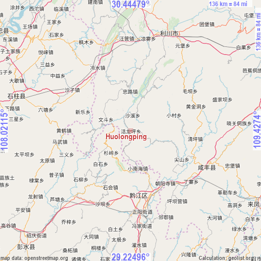
| Map corner | latitude | longitude |
|---|---|---|
| Upper-left | 30.44479°, | 108.02115° |
| Center: | 29.83674°, | 108.72427° |
| Lower-right: | 29.22496°, | 109.4274° |
| Map W x H: | 135.6×135.6 km | = 84.3×84.3mi |
| max Lat: | 53.31946° ⇑55.9% North |
| Huolongping: | 29.83674° |
| min Lat: | ⇓44.1% South 18.22056° |
| min Long | Huolongping | max Long |
| 75.07348° | 108.72427° | 134.28917° |
| W 22.4%⇐ | ⇒77.6% E |
Elevation
Elevation of Huolongping is 821 m = 2694 ft, and this is 336.2 m = 1103 ft above average elevation for this country.
| Max E: |
5622 m = 18445 ft | 17.5% |
| Huolongping | 821 m 2694 ft | |
| Avg. | 484.8 m = 1591 ft | |
Min E: |
-3 m = -10 ft | 82.5% |
See also: China elevation on elevation.city.
Geographical zone
Huolongping is located in North temperate zone (between Tropic of Cancer and the Arctic Circle). Distance of this Northern Tropic circle is 711.6 km =442.2 mi to South.| Distance of | km | miles | from Huolongping |
|---|---|---|---|
| North Pole | 6689.5 | 4156.7 | to North |
| Arctic Circle | 4083.6 | 2537.4 | to North |
| Tropic Cancer | 711.6 | 442.2 | to South |
| Equator | 3317.5 | 2061.4 | to South |


Nearby cities:
15 places around Huolongping: (largest is in red/bold)
• Baishi
23.1 km =14.4 mi,  222°
222°
• Heixi
29.9 km =18.6 mi, 216°
• Huangxi
14.3 km =8.9 mi,  237°
237°
• Jianshan
30.4 km =18.9 mi,  119°
119°
• Jinling
28.1 km =17.5 mi,  308°
308°
• Lishui
7.8 km =4.8 mi,  264°
264°
• Shanling
15 km =9.3 mi, 222°
• Shaxi
8.2 km =5.1 mi,  7°
7°
• Shihui
31.5 km =19.6 mi,  200°
200°
• Wendou
14.2 km =8.8 mi,  295°
295°
• Xiaocun
23.9 km =14.9 mi,  69°
69°
• Xiaonanhai
19.8 km =12.3 mi,  169°
169°
• Xinle
26.7 km =16.6 mi,  292°
292°
• Zhonglu
20.6 km =12.8 mi,  358°
358°
• Zhongtang
26.9 km =16.7 mi,  158°
158°
Sources, notices
• [Note1] Compared only with cities in China existing in our database
• [Src1] Map data: © OpenStreetMap contributors (CC-BY-SA)
• [Src2] Other city data from geonames.org with taken over terms of usage.
• [Src3] Geographical zone / Annual Mean Temperature by Robert A. Rohde @ Wikipedia
