Wendou geodata
Wendou (Hubei) is a seat of a fourth-order administrative division; located in China in Asia/Shanghai (GMT+8) time zone. In our database, there are 1268 cities with bigger population. Compared to other cities in China, 55.2% of cities are located further ↑North; 78.2% of cities are located further →East and 87.9% of cities have lower elevation than Wendou. Note1


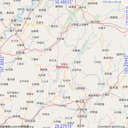
Wendou GPS coordinates[2]
29° 53' 26.268" North, 108° 35' 28.752" East
| Map corner | latitude | longitude |
|---|---|---|
| Upper-left | 30.49835°, | 107.8882° |
| Center: | 29.89063°, | 108.59132° |
| Lower-right: | 29.27918°, | 109.29445° |
| Map W x H: | 135.6×135.6 km | = 84.3×84.3mi |
| max Lat: | 53.31946° ⇑55.2% North |
| Wendou: | 29.89063° |
| min Lat: | ⇓44.8% South 18.22056° |
| min Long | Wendou | max Long |
| 75.07348° | 108.59132° | 134.28917° |
| W 21.8%⇐ | ⇒78.2% E |
Elevation
Elevation of Wendou is 1176 m = 3858 ft, and this is 691.2 m = 2268 ft above average elevation for this country.
| Max E: |
5622 m = 18445 ft | 12.1% |
| Wendou | 1176 m 3858 ft | |
| Avg. | 484.8 m = 1591 ft | |
Min E: |
-3 m = -10 ft | 87.9% |
See also: China elevation on elevation.city.
Geographical zone
Wendou is located in North temperate zone (between Tropic of Cancer and the Arctic Circle). Distance of this Northern Tropic circle is 717.6 km =445.9 mi to South.| Distance of | km | miles | from Wendou |
|---|---|---|---|
| North Pole | 6683.5 | 4152.9 | to North |
| Arctic Circle | 4077.6 | 2533.7 | to North |
| Tropic Cancer | 717.6 | 445.9 | to South |
| Equator | 3323.5 | 2065.1 | to South |


Nearby cities:
15 places around Wendou: (largest is in red/bold)
• Baishi
23.2 km =14.4 mi,  186°
186°
• Huanghe
22.6 km =14 mi,  255°
255°
• Huangxi
13.7 km =8.5 mi,  176°
176°
• Huolongping
14.2 km =8.8 mi,  115°
115°
• Jinling
14.7 km =9.1 mi,  320°
320°
• Lengshui
27 km =16.8 mi,  350°
350°
• Lianhu
26.2 km =16.3 mi,  215°
215°
• Lishui
8.4 km =5.2 mi,  143°
143°
• Mawu
26.4 km =16.4 mi,  244°
244°
• Shanling
17.4 km =10.8 mi,  170°
170°
• Shaxi
14.1 km =8.8 mi,  81°
81°
• Shazi
23.3 km =14.5 mi,  310°
310°
• Xinle
12.6 km =7.8 mi,  288°
288°
• Xixin
19.2 km =11.9 mi,  279°
279°
• Zhonglu
19.2 km =11.9 mi,  40°
40°
Sources, notices
• [Note1] Compared only with cities in China existing in our database
• [Src1] Map data: © OpenStreetMap contributors (CC-BY-SA)
• [Src2] Other city data from geonames.org with taken over terms of usage.
• [Src3] Geographical zone / Annual Mean Temperature by Robert A. Rohde @ Wikipedia
