Baishi geodata
Baishi (Chongqing) is a seat of a fourth-order administrative division; located in China in Asia/Shanghai (GMT+8) time zone. In our database, there are 1268 cities with bigger population. Compared to other cities in China, 57.7% of cities are located further ↑North; 78.3% of cities are located further →East and 71.3% of cities have lower elevation than Baishi. Note1


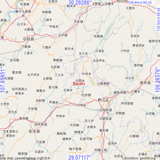
Baishi GPS coordinates[2]
29° 41' 1.932" North, 108° 33' 45.468" East
| Map corner | latitude | longitude |
|---|---|---|
| Upper-left | 30.29286°, | 107.85951° |
| Center: | 29.68387°, | 108.56263° |
| Lower-right: | 29.07117°, | 109.26576° |
| Map W x H: | 135.8×135.8 km | = 84.4×84.4mi |
| max Lat: | 53.31946° ⇑57.7% North |
| Baishi: | 29.68387° |
| min Lat: | ⇓42.3% South 18.22056° |
| min Long | Baishi | max Long |
| 75.07348° | 108.56263° | 134.28917° |
| W 21.7%⇐ | ⇒78.3% E |
Elevation
Elevation of Baishi is 437 m = 1434 ft, and this is 47.8 m = 157 ft below average elevation for this country.
| Max E: |
5622 m = 18445 ft | 28.7% |
| Avg. | 484.8 m = 1591 ft | |
| Baishi | 437 m = 1434 ft | |
Min E: |
-3 m = -10 ft | 71.3% |
See also: China elevation on elevation.city.
Geographical zone
Baishi is located in North temperate zone (between Tropic of Cancer and the Arctic Circle). Distance of this Northern Tropic circle is 694.6 km =431.6 mi to South.| Distance of | km | miles | from Baishi |
|---|---|---|---|
| North Pole | 6706.5 | 4167.2 | to North |
| Arctic Circle | 4100.6 | 2548 | to North |
| Tropic Cancer | 694.6 | 431.6 | to South |
| Equator | 3300.5 | 2050.8 | to South |


Nearby cities:
15 places around Baishi: (largest is in red/bold)
• Heixi
7.3 km =4.5 mi,  196°
196°
• Huangxi
10 km =6.2 mi,  21°
21°
• Huolongping
23.1 km =14.4 mi,  42°
42°
• Lianhe
16.6 km =10.3 mi,  232°
232°
• Lianhu
12.4 km =7.7 mi,  277°
277°
• Lishui
18.1 km =11.2 mi,  25°
25°
• Longxi
24.3 km =15.1 mi,  190°
190°
• Mawu
23.9 km =14.9 mi,  298°
298°
• Puzi
23.3 km =14.5 mi,  255°
255°
• Shaba
21.6 km =13.4 mi,  174°
174°
• Shanling
8 km =5 mi, 43°
• Shihui
13.3 km =8.3 mi,  159°
159°
• Wendou
23.2 km =14.4 mi,  6°
6°
• Xiaonanhai
19.5 km =12.1 mi,  97°
97°
• Yushan
21.4 km =13.3 mi,  218°
218°
Sources, notices
• [Note1] Compared only with cities in China existing in our database
• [Src1] Map data: © OpenStreetMap contributors (CC-BY-SA)
• [Src2] Other city data from geonames.org with taken over terms of usage.
• [Src3] Geographical zone / Annual Mean Temperature by Robert A. Rohde @ Wikipedia
