Huangyan geodata
Huangyan (Zhejiang) is a populated place; located in China in Asia/Shanghai (GMT+8) time zone. With population of 150,448 people, there are 298 cities with bigger population in this country. Compared to other cities in China, 68.4% of cities are located further ↑North; 88.9% of cities are located further ←West and 89.9% of cities have higher elevation than Huangyan. Note1


Huangyan GPS coordinates[2]
28° 39' 0.36" North, 121° 15' 57.276" East
| Map corner | latitude | longitude |
|---|---|---|
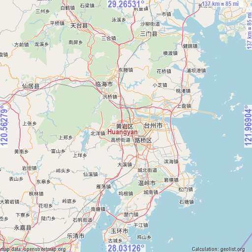
| Upper-left | 29.26531°, | 120.56279° |
| Center: | 28.6501°, | 121.26591° |
| Lower-right: | 28.03126°, | 121.96904° |
| Map W x H: | 137.2×137.2 km | = 85.3×85.3mi |
| max Lat: | 53.31946° ⇑68.4% North |
| Huangyan: | 28.6501° |
| min Lat: | ⇓31.6% South 18.22056° |
| min Long | Huangyan | max Long |
| 75.07348° | 121.26591° | 134.28917° |
| W 88.9%⇐ | ⇒11.1% E |
Elevation
Elevation of Huangyan is 10 m = 33 ft, and this is 474.8 m = 1558 ft below average elevation for this country.
| Max E: |
5622 m = 18445 ft | 89.9% |
| Avg. | 484.8 m = 1591 ft | |
| Huangyan | 10 m = 33 ft | |
Min E: |
-3 m = -10 ft | 10.1% |
See also: Huangyan elevation on elevation.city.
Geographical zone
Huangyan is located in North temperate zone (between Tropic of Cancer and the Arctic Circle). Distance of this Northern Tropic circle is 579.7 km =360.2 mi to South.| Distance of | km | miles | from Huangyan |
|---|---|---|---|
| North Pole | 6821.5 | 4238.7 | to North |
| Arctic Circle | 4215.6 | 2619.5 | to North |
| Tropic Cancer | 579.7 | 360.2 | to South |
| Equator | 3185.6 | 1979.4 | to South |


Nearby cities:
15 places around Huangyan: (largest is in red/bold)
• Beicheng
2.8 km =1.7 mi,  343°
343°
• Dengjiang
6.5 km =4 mi,  249°
249°
• Dongcheng
0.6 km =0.4 mi,  121°
121°
• Gaoqiao
7.8 km =4.8 mi,  208°
208°
• Jiangkou
5.9 km =3.7 mi,  59°
59°
• Jiazhi
11.2 km =7 mi,  76°
76°
• Lubei
12.4 km =7.7 mi, 124°
• Nancheng
4.3 km =2.7 mi,  183°
183°
• Shabu
11.9 km =7.4 mi,  216°
216°
• Tongyu
9 km =5.6 mi,  135°
135°
• Toutuo
12.3 km =7.6 mi,  259°
259°
• Xicheng
1.1 km =0.7 mi,  228°
228°
• Xinqian
5.7 km =3.5 mi,  278°
278°
• Yanjiang
10.8 km =6.7 mi, 344°
• Yuanqiao
11 km =6.8 mi,  188°
188°
Sources, notices
• [Note1] Compared only with cities in China existing in our database
• [Src1] Map data: © OpenStreetMap contributors (CC-BY-SA)
• [Src2] Other city data from geonames.org with taken over terms of usage.
• [Src3] Geographical zone / Annual Mean Temperature by Robert A. Rohde @ Wikipedia
