Jiangkou geodata
Jiangkou (Zhejiang) is a seat of a fourth-order administrative division; located in China in Asia/Shanghai (GMT+8) time zone. In our database, there are 1268 cities with bigger population. Compared to other cities in China, 68.2% of cities are located further ↑North; 89.2% of cities are located further ←West and 91.2% of cities have higher elevation than Jiangkou. Note1


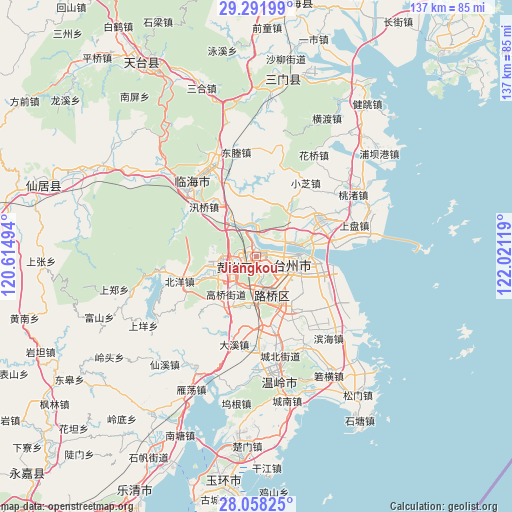
Jiangkou GPS coordinates[2]
28° 40' 36.984" North, 121° 19' 5.016" East
| Map corner | latitude | longitude |
|---|---|---|
| Upper-left | 29.29199°, | 120.61494° |
| Center: | 28.67694°, | 121.31806° |
| Lower-right: | 28.05825°, | 122.02119° |
| Map W x H: | 137.2×137.2 km | = 85.3×85.3mi |
| max Lat: | 53.31946° ⇑68.2% North |
| Jiangkou: | 28.67694° |
| min Lat: | ⇓31.8% South 18.22056° |
| min Long | Jiangkou | max Long |
| 75.07348° | 121.31806° | 134.28917° |
| W 89.2%⇐ | ⇒10.8% E |
Elevation
Elevation of Jiangkou is 9 m = 30 ft, and this is 475.8 m = 1561 ft below average elevation for this country.
| Max E: |
5622 m = 18445 ft | 91.2% |
| Avg. | 484.8 m = 1591 ft | |
| Jiangkou | 9 m = 30 ft | |
Min E: |
-3 m = -10 ft | 8.8% |
See also: China elevation on elevation.city.
Geographical zone
Jiangkou is located in North temperate zone (between Tropic of Cancer and the Arctic Circle). Distance of this Northern Tropic circle is 582.7 km =362.1 mi to South.| Distance of | km | miles | from Jiangkou |
|---|---|---|---|
| North Pole | 6818.5 | 4236.8 | to North |
| Arctic Circle | 4212.6 | 2617.6 | to North |
| Tropic Cancer | 582.7 | 362.1 | to South |
| Equator | 3188.6 | 1981.3 | to South |


Nearby cities:
15 places around Jiangkou: (largest is in red/bold)
• Baiyun
8.6 km =5.3 mi,  89°
89°
• Beicheng
5.9 km =3.7 mi,  267°
267°
• Dongcheng
5.6 km =3.5 mi,  234°
234°
• Haimen
10.4 km =6.5 mi, 87°
• Huangyan
5.9 km =3.7 mi,  239°
239°
• Jiazhi
5.8 km =3.6 mi, 93°
• Lubei
11.3 km =7 mi,  153°
153°
• Nancheng
9 km =5.6 mi,  216°
216°
• Taizhou
11.3 km =7 mi,  98°
98°
• Tongyu
9.5 km =5.9 mi,  172°
172°
• Xicheng
7 km =4.3 mi, 237°
• Xinqian
10.9 km =6.8 mi,  258°
258°
• Yanjiang
10.9 km =6.8 mi,  312°
312°
• Yongquan
9.5 km =5.9 mi,  359°
359°
• Zhang’an
9.9 km =6.2 mi,  64°
64°
Sources, notices
• [Note1] Compared only with cities in China existing in our database
• [Src1] Map data: © OpenStreetMap contributors (CC-BY-SA)
• [Src2] Other city data from geonames.org with taken over terms of usage.
• [Src3] Geographical zone / Annual Mean Temperature by Robert A. Rohde @ Wikipedia
