Dengjiang geodata
Dengjiang (Zhejiang) is a seat of a fourth-order administrative division; located in China in Asia/Shanghai (GMT+8) time zone. In our database, there are 1268 cities with bigger population. Compared to other cities in China, 68.6% of cities are located further ↑North; 88.6% of cities are located further ←West and 94.3% of cities have higher elevation than Dengjiang. Note1


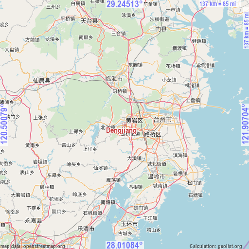
Dengjiang GPS coordinates[2]
28° 37' 47.28" North, 121° 12' 14.076" East
| Map corner | latitude | longitude |
|---|---|---|
| Upper-left | 29.24513°, | 120.50079° |
| Center: | 28.6298°, | 121.20391° |
| Lower-right: | 28.01084°, | 121.90704° |
| Map W x H: | 137.2×137.2 km | = 85.3×85.3mi |
| max Lat: | 53.31946° ⇑68.6% North |
| Dengjiang: | 28.6298° |
| min Lat: | ⇓31.4% South 18.22056° |
| min Long | Dengjiang | max Long |
| 75.07348° | 121.20391° | 134.28917° |
| W 88.6%⇐ | ⇒11.4% E |
Elevation
Elevation of Dengjiang is 7 m = 23 ft, and this is 477.8 m = 1568 ft below average elevation for this country.
| Max E: |
5622 m = 18445 ft | 94.3% |
| Avg. | 484.8 m = 1591 ft | |
| Dengjiang | 7 m = 23 ft | |
Min E: |
-3 m = -10 ft | 5.7% |
See also: China elevation on elevation.city.
Geographical zone
Dengjiang is located in North temperate zone (between Tropic of Cancer and the Arctic Circle). Distance of this Northern Tropic circle is 577.4 km =358.8 mi to South.| Distance of | km | miles | from Dengjiang |
|---|---|---|---|
| North Pole | 6823.7 | 4240 | to North |
| Arctic Circle | 4217.8 | 2620.8 | to North |
| Tropic Cancer | 577.4 | 358.8 | to South |
| Equator | 3183.3 | 1978 | to South |


Nearby cities:
15 places around Dengjiang: (largest is in red/bold)
• Beicheng
7.2 km =4.5 mi,  46°
46°
• Beiyang
9.6 km =6 mi,  261°
261°
• Dongcheng
6.8 km =4.2 mi,  73°
73°
• Gaoqiao
5.1 km =3.2 mi,  152°
152°
• Huangyan
6.5 km =4 mi, 69°
• Jiangkou
12.3 km =7.6 mi,  64°
64°
• Maoshe
9.8 km =6.1 mi,  233°
233°
• Nancheng
6.1 km =3.8 mi,  109°
109°
• Shabu
7.4 km =4.6 mi,  187°
187°
• Tongyu
13.1 km =8.1 mi, 108°
• Toutuo
6 km =3.7 mi,  270°
270°
• Xicheng
5.4 km =3.4 mi, 73°
• Xinqian
3.2 km =2 mi,  7°
7°
• Yanjiang
13 km =8.1 mi, 13°
• Yuanqiao
9.6 km =6 mi, 152°
Sources, notices
• [Note1] Compared only with cities in China existing in our database
• [Src1] Map data: © OpenStreetMap contributors (CC-BY-SA)
• [Src2] Other city data from geonames.org with taken over terms of usage.
• [Src3] Geographical zone / Annual Mean Temperature by Robert A. Rohde @ Wikipedia
