Huangkeng geodata
Huangkeng (Guangdong) is a seat of a fourth-order administrative division; located in China in Asia/Shanghai (GMT+8) time zone. In our database, there are 1268 cities with bigger population. Compared to other cities in China, 85.5% of cities are located further ↑North; 51.6% of cities are located further ←West and 50.2% of cities have higher elevation than Huangkeng. Note1


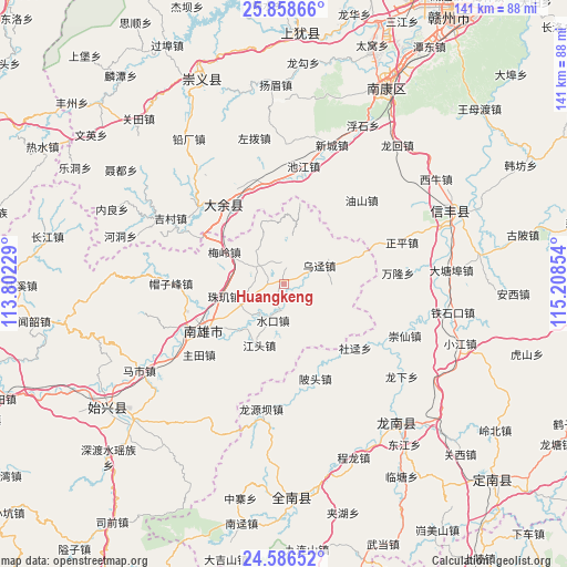
Huangkeng GPS coordinates[2]
25° 13' 27.3" North, 114° 30' 19.476" East
| Map corner | latitude | longitude |
|---|---|---|
| Upper-left | 25.85866°, | 113.80229° |
| Center: | 25.22425°, | 114.50541° |
| Lower-right: | 24.58652°, | 115.20854° |
| Map W x H: | 141.4×141.5 km | = 87.9×87.9mi |
| max Lat: | 53.31946° ⇑85.5% North |
| Huangkeng: | 25.22425° |
| min Lat: | ⇓14.5% South 18.22056° |
| min Long | Huangkeng | max Long |
| 75.07348° | 114.50541° | 134.28917° |
| W 51.6%⇐ | ⇒48.4% E |
Elevation
Elevation of Huangkeng is 163 m = 535 ft, and this is 321.8 m = 1056 ft below average elevation for this country.
| Max E: |
5622 m = 18445 ft | 50.2% |
| Avg. | 484.8 m = 1591 ft | |
| Huangkeng | 163 m = 535 ft | |
Min E: |
-3 m = -10 ft | 49.8% |
See also: China elevation on elevation.city.
Geographical zone
Huangkeng is located in North temperate zone (between Tropic of Cancer and the Arctic Circle). Distance of this Northern Tropic circle is 198.8 km =123.5 mi to South.| Distance of | km | miles | from Huangkeng |
|---|---|---|---|
| North Pole | 7202.4 | 4475.4 | to North |
| Arctic Circle | 4596.5 | 2856.1 | to North |
| Tropic Cancer | 198.8 | 123.5 | to South |
| Equator | 2804.7 | 1742.8 | to South |


Nearby cities:
15 places around Huangkeng: (largest is in red/bold)
• Datang
6.6 km =4.1 mi,  17°
17°
• Dengfang
7.6 km =4.7 mi,  304°
304°
• Hukou
11.9 km =7.4 mi,  241°
241°
• Jiangtou
16.5 km =10.3 mi,  201°
201°
• Jiezhi
21.3 km =13.2 mi,  84°
84°
• Kongjiang
12.9 km =8 mi,  60°
60°
• Meiling
16.9 km =10.5 mi, 297°
• Nanmu
8.6 km =5.3 mi,  143°
143°
• Pingtian
12.5 km =7.8 mi,  106°
106°
• Shuikou
9.5 km =5.9 mi, 196°
• Wujing
11.1 km =6.9 mi,  73°
73°
• Xinlong
12.1 km =7.5 mi,  103°
103°
• Xiongzhou
23.9 km =14.9 mi, 239°
• Youshan
15.5 km =9.6 mi,  13°
13°
• Zhuji
15.3 km =9.5 mi,  253°
253°
Sources, notices
• [Note1] Compared only with cities in China existing in our database
• [Src1] Map data: © OpenStreetMap contributors (CC-BY-SA)
• [Src2] Other city data from geonames.org with taken over terms of usage.
• [Src3] Geographical zone / Annual Mean Temperature by Robert A. Rohde @ Wikipedia
