Huangjinbu geodata
Huangjinbu (Jiangxi) is a seat of a fourth-order administrative division; located in China in Asia/Shanghai (GMT+8) time zone. In our database, there are 1268 cities with bigger population. Compared to other cities in China, 69.9% of cities are located further ↑North; 65% of cities are located further ←West and 80.8% of cities have higher elevation than Huangjinbu. Note1


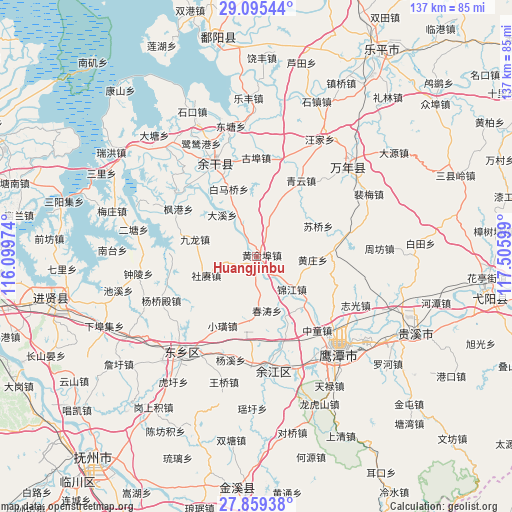
Huangjinbu GPS coordinates[2]
28° 28' 45.192" North, 116° 48' 10.296" East
| Map corner | latitude | longitude |
|---|---|---|
| Upper-left | 29.09544°, | 116.09974° |
| Center: | 28.47922°, | 116.80286° |
| Lower-right: | 27.85938°, | 117.50599° |
| Map W x H: | 137.4×137.4 km | = 85.4×85.4mi |
| max Lat: | 53.31946° ⇑69.9% North |
| Huangjinbu: | 28.47922° |
| min Lat: | ⇓30.1% South 18.22056° |
| min Long | Huangjinbu | max Long |
| 75.07348° | 116.80286° | 134.28917° |
| W 65%⇐ | ⇒35% E |
Elevation
Elevation of Huangjinbu is 25 m = 82 ft, and this is 459.8 m = 1509 ft below average elevation for this country.
| Max E: |
5622 m = 18445 ft | 80.8% |
| Avg. | 484.8 m = 1591 ft | |
| Huangjinbu | 25 m = 82 ft | |
Min E: |
-3 m = -10 ft | 19.2% |
See also: China elevation on elevation.city.
Geographical zone
Huangjinbu is located in North temperate zone (between Tropic of Cancer and the Arctic Circle). Distance of this Northern Tropic circle is 560.7 km =348.4 mi to South.| Distance of | km | miles | from Huangjinbu |
|---|---|---|---|
| North Pole | 6840.5 | 4250.5 | to North |
| Arctic Circle | 4234.6 | 2631.3 | to North |
| Tropic Cancer | 560.7 | 348.4 | to South |
| Equator | 3166.6 | 1967.6 | to South |


Nearby cities:
15 places around Huangjinbu: (largest is in red/bold)
• Baimaqiao
19 km =11.8 mi,  340°
340°
• Chuntaoxiang
14.7 km =9.1 mi,  169°
169°
• Daxi
15.8 km =9.8 mi,  319°
319°
• Huangxi
17.7 km =11 mi,  155°
155°
• Huangzhuang
14.5 km =9 mi,  90°
90°
• Jinjiang
12.9 km =8 mi,  132°
132°
• Jiulong
17.2 km =10.7 mi,  285°
285°
• Meigang
4.8 km =3 mi, 166°
• Pingdingxiang
22.1 km =13.7 mi, 159°
• Pogan
17 km =10.6 mi,  186°
186°
• Qingyun
23.6 km =14.7 mi,  30°
30°
• Shegeng
14.5 km =9 mi,  250°
250°
• Suqiaoxiang
17.1 km =10.6 mi,  46°
46°
• Wuleixiang
12 km =7.5 mi,  18°
18°
• Xiaohuang
20.7 km =12.9 mi,  206°
206°
Sources, notices
• [Note1] Compared only with cities in China existing in our database
• [Src1] Map data: © OpenStreetMap contributors (CC-BY-SA)
• [Src2] Other city data from geonames.org with taken over terms of usage.
• [Src3] Geographical zone / Annual Mean Temperature by Robert A. Rohde @ Wikipedia
