Shegeng geodata
Shegeng (Jiangxi) is a seat of a fourth-order administrative division; located in China in Asia/Shanghai (GMT+8) time zone. In our database, there are 1268 cities with bigger population. Compared to other cities in China, 70.2% of cities are located further ↑North; 64.1% of cities are located further ←West and 71.3% of cities have higher elevation than Shegeng. Note1


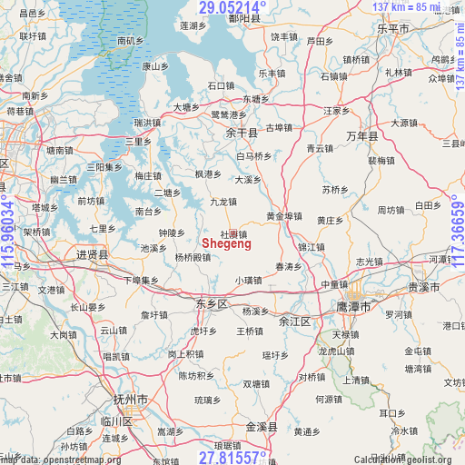
Shegeng GPS coordinates[2]
28° 26' 8.376" North, 116° 39' 48.456" East
| Map corner | latitude | longitude |
|---|---|---|
| Upper-left | 29.05214°, | 115.96034° |
| Center: | 28.43566°, | 116.66346° |
| Lower-right: | 27.81557°, | 117.36659° |
| Map W x H: | 137.5×137.5 km | = 85.4×85.4mi |
| max Lat: | 53.31946° ⇑70.2% North |
| Shegeng: | 28.43566° |
| min Lat: | ⇓29.8% South 18.22056° |
| min Long | Shegeng | max Long |
| 75.07348° | 116.66346° | 134.28917° |
| W 64.1%⇐ | ⇒35.9% E |
Elevation
Elevation of Shegeng is 47 m = 154 ft, and this is 437.8 m = 1436 ft below average elevation for this country.
| Max E: |
5622 m = 18445 ft | 71.3% |
| Avg. | 484.8 m = 1591 ft | |
| Shegeng | 47 m = 154 ft | |
Min E: |
-3 m = -10 ft | 28.7% |
See also: China elevation on elevation.city.
Geographical zone
Shegeng is located in North temperate zone (between Tropic of Cancer and the Arctic Circle). Distance of this Northern Tropic circle is 555.8 km =345.4 mi to South.| Distance of | km | miles | from Shegeng |
|---|---|---|---|
| North Pole | 6845.3 | 4253.5 | to North |
| Arctic Circle | 4239.4 | 2634.2 | to North |
| Tropic Cancer | 555.8 | 345.4 | to South |
| Equator | 3161.7 | 1964.6 | to South |


Nearby cities:
15 places around Shegeng: (largest is in red/bold)
• Chuntaoxiang
19 km =11.8 mi,  120°
120°
• Daxi
17.3 km =10.7 mi,  11°
11°
• Dengdun
9.4 km =5.8 mi,  244°
244°
• Dengjiaxiang
22.7 km =14.1 mi,  206°
206°
• Fenggang
19.1 km =11.9 mi,  336°
336°
• Heshan
21.1 km =13.1 mi,  328°
328°
• Huangjinbu
14.5 km =9 mi,  70°
70°
• Jiangbu
23.2 km =14.4 mi, 339°
• Jinjiang
23.4 km =14.5 mi,  99°
99°
• Jiulong
10 km =6.2 mi, 342°
• Meigang
14.8 km =9.2 mi,  89°
89°
• Pogan
16.8 km =10.4 mi,  135°
135°
• Xiaohuang
14.5 km =9 mi,  161°
161°
• Yangqiaodian
13.9 km =8.6 mi, 239°
• Zhongling
18.2 km =11.3 mi,  270°
270°
Sources, notices
• [Note1] Compared only with cities in China existing in our database
• [Src1] Map data: © OpenStreetMap contributors (CC-BY-SA)
• [Src2] Other city data from geonames.org with taken over terms of usage.
• [Src3] Geographical zone / Annual Mean Temperature by Robert A. Rohde @ Wikipedia
