Qingyun geodata
Qingyun (Jiangxi) is a seat of a fourth-order administrative division; located in China in Asia/Shanghai (GMT+8) time zone. In our database, there are 1268 cities with bigger population. Compared to other cities in China, 68.3% of cities are located further ↑North; 65.6% of cities are located further ←West and 77.7% of cities have higher elevation than Qingyun. Note1


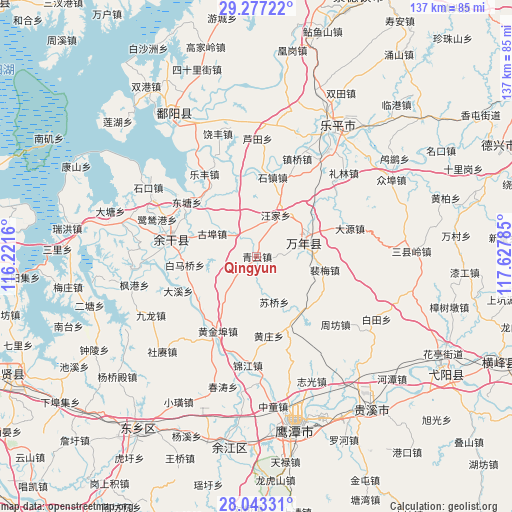
Qingyun GPS coordinates[2]
28° 39' 43.488" North, 116° 55' 28.992" East
| Map corner | latitude | longitude |
|---|---|---|
| Upper-left | 29.27722°, | 116.2216° |
| Center: | 28.66208°, | 116.92472° |
| Lower-right: | 28.04331°, | 117.62785° |
| Map W x H: | 137.2×137.2 km | = 85.3×85.3mi |
| max Lat: | 53.31946° ⇑68.3% North |
| Qingyun: | 28.66208° |
| min Lat: | ⇓31.7% South 18.22056° |
| min Long | Qingyun | max Long |
| 75.07348° | 116.92472° | 134.28917° |
| W 65.6%⇐ | ⇒34.4% E |
Elevation
Elevation of Qingyun is 31 m = 102 ft, and this is 453.8 m = 1489 ft below average elevation for this country.
| Max E: |
5622 m = 18445 ft | 77.7% |
| Avg. | 484.8 m = 1591 ft | |
| Qingyun | 31 m = 102 ft | |
Min E: |
-3 m = -10 ft | 22.3% |
See also: China elevation on elevation.city.
Geographical zone
Qingyun is located in North temperate zone (between Tropic of Cancer and the Arctic Circle). Distance of this Northern Tropic circle is 581 km =361 mi to South.| Distance of | km | miles | from Qingyun |
|---|---|---|---|
| North Pole | 6820.1 | 4237.8 | to North |
| Arctic Circle | 4214.2 | 2618.6 | to North |
| Tropic Cancer | 581 | 361 | to South |
| Equator | 3186.9 | 1980.2 | to South |


Nearby cities:
15 places around Qingyun: (largest is in red/bold)
• Baimaqiao
18.4 km =11.4 mi,  262°
262°
• Chenying
14.3 km =8.9 mi,  76°
76°
• Dahuang
13.5 km =8.4 mi,  3°
3°
• Gubu
13.5 km =8.4 mi,  297°
297°
• Huangzhuang
20.7 km =12.9 mi,  172°
172°
• Huaqiao
19.9 km =12.4 mi,  144°
144°
• Huyunxiang
18.4 km =11.4 mi,  322°
322°
• Peimei
17.6 km =10.9 mi,  98°
98°
• Qibu
8.9 km =5.5 mi, 318°
• Shangfang
12 km =7.5 mi, 81°
• Suqiaoxiang
8.5 km =5.3 mi,  177°
177°
• Wangjia
5.4 km =3.4 mi,  14°
14°
• Wuleixiang
12.1 km =7.5 mi,  222°
222°
• Zhushan
14.6 km =9.1 mi,  70°
70°
• Zhutian
18.6 km =11.6 mi,  54°
54°
Sources, notices
• [Note1] Compared only with cities in China existing in our database
• [Src1] Map data: © OpenStreetMap contributors (CC-BY-SA)
• [Src2] Other city data from geonames.org with taken over terms of usage.
• [Src3] Geographical zone / Annual Mean Temperature by Robert A. Rohde @ Wikipedia
