Huangbei geodata
Huangbei (Guangdong) is a seat of a fourth-order administrative division; located in China in Asia/Shanghai (GMT+8) time zone. In our database, there are 1268 cities with bigger population. Compared to other cities in China, 88.8% of cities are located further ↑North; 58.4% of cities are located further ←West and 51.9% of cities have lower elevation than Huangbei. Note1


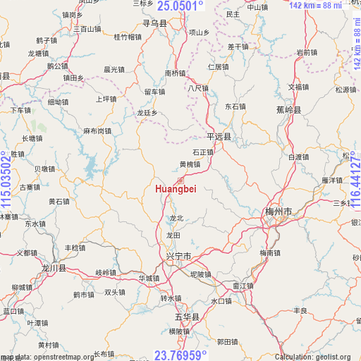
Huangbei GPS coordinates[2]
24° 24' 41.292" North, 115° 44' 17.304" East
| Map corner | latitude | longitude |
|---|---|---|
| Upper-left | 25.0501°, | 115.03502° |
| Center: | 24.41147°, | 115.73814° |
| Lower-right: | 23.76959°, | 116.44127° |
| Map W x H: | 142.4×142.4 km | = 88.5×88.5mi |
| max Lat: | 53.31946° ⇑88.8% North |
| Huangbei: | 24.41147° |
| min Lat: | ⇓11.2% South 18.22056° |
| min Long | Huangbei | max Long |
| 75.07348° | 115.73814° | 134.28917° |
| W 58.4%⇐ | ⇒41.6% E |
Elevation
Elevation of Huangbei is 180 m = 591 ft, and this is 304.8 m = 1000 ft below average elevation for this country.
| Max E: |
5622 m = 18445 ft | 48.1% |
| Avg. | 484.8 m = 1591 ft | |
| Huangbei | 180 m = 591 ft | |
Min E: |
-3 m = -10 ft | 51.9% |
See also: China elevation on elevation.city.
Geographical zone
Huangbei is located in North temperate zone (between Tropic of Cancer and the Arctic Circle). Distance of this Northern Tropic circle is 108.4 km =67.4 mi to South.| Distance of | km | miles | from Huangbei |
|---|---|---|---|
| North Pole | 7292.8 | 4531.5 | to North |
| Arctic Circle | 4686.9 | 2912.3 | to North |
| Tropic Cancer | 108.4 | 67.4 | to South |
| Equator | 2714.3 | 1686.6 | to South |


Nearby cities:
15 places around Huangbei: (largest is in red/bold)
• Chaozhu
21.5 km =13.4 mi,  49°
49°
• Daping
18.7 km =11.6 mi,  240°
240°
• Gangbei
9 km =5.6 mi,  207°
207°
• Heshui
18.5 km =11.5 mi,  192°
192°
• Huanghuai
7.4 km =4.6 mi,  30°
30°
• Huilong
22 km =13.7 mi,  257°
257°
• Longbei
14.2 km =8.8 mi, 185°
• Longtian
21.6 km =13.4 mi, 187°
• Luofu
20.6 km =12.8 mi,  308°
308°
• Luogang
11.1 km =6.9 mi,  278°
278°
• Meixi
12.7 km =7.9 mi,  67°
67°
• Pingyang
11.7 km =7.3 mi,  216°
216°
• Shikeng
9.5 km =5.9 mi,  104°
104°
• Shima
16.5 km =10.3 mi,  147°
147°
• Shizheng
14.6 km =9.1 mi,  37°
37°
Sources, notices
• [Note1] Compared only with cities in China existing in our database
• [Src1] Map data: © OpenStreetMap contributors (CC-BY-SA)
• [Src2] Other city data from geonames.org with taken over terms of usage.
• [Src3] Geographical zone / Annual Mean Temperature by Robert A. Rohde @ Wikipedia
