Pingyang geodata
Pingyang (Guangdong) is a seat of a fourth-order administrative division; located in China in Asia/Shanghai (GMT+8) time zone. In our database, there are 1268 cities with bigger population. Compared to other cities in China, 89.1% of cities are located further ↑North; 58% of cities are located further ←West and 51.3% of cities have higher elevation than Pingyang. Note1


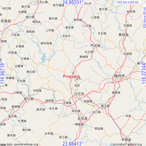
Pingyang GPS coordinates[2]
24° 19' 35.184" North, 115° 40' 13.116" East
| Map corner | latitude | longitude |
|---|---|---|
| Upper-left | 24.96551°, | 114.96719° |
| Center: | 24.32644°, | 115.67031° |
| Lower-right: | 23.68413°, | 116.37344° |
| Map W x H: | 142.5×142.5 km | = 88.5×88.5mi |
| max Lat: | 53.31946° ⇑89.1% North |
| Pingyang: | 24.32644° |
| min Lat: | ⇓10.9% South 18.22056° |
| min Long | Pingyang | max Long |
| 75.07348° | 115.67031° | 134.28917° |
| W 58%⇐ | ⇒42% E |
Elevation
Elevation of Pingyang is 154 m = 505 ft, and this is 330.8 m = 1085 ft below average elevation for this country.
| Max E: |
5622 m = 18445 ft | 51.3% |
| Avg. | 484.8 m = 1591 ft | |
| Pingyang | 154 m = 505 ft | |
Min E: |
-3 m = -10 ft | 48.7% |
See also: China elevation on elevation.city.
Geographical zone
Pingyang is located in North temperate zone (between Tropic of Cancer and the Arctic Circle). Distance of this Northern Tropic circle is 98.9 km =61.5 mi to South.| Distance of | km | miles | from Pingyang |
|---|---|---|---|
| North Pole | 7302.2 | 4537.4 | to North |
| Arctic Circle | 4696.3 | 2918.1 | to North |
| Tropic Cancer | 98.9 | 61.5 | to South |
| Equator | 2704.8 | 1680.7 | to South |


Nearby cities:
15 places around Pingyang: (largest is in red/bold)
• Daping
9.3 km =5.8 mi,  270°
270°
• Gangbei
3.1 km =1.9 mi,  61°
61°
• Heshui
9.1 km =5.7 mi,  161°
161°
• Huangbei
11.7 km =7.3 mi,  36°
36°
• Huanghuai
19 km =11.8 mi,  33°
33°
• Huilong
15.4 km =9.6 mi,  288°
288°
• Longbei
7.3 km =4.5 mi,  130°
130°
• Longtian
12.6 km =7.8 mi, 161°
• Luogang
11.9 km =7.4 mi,  339°
339°
• Ningtang
18.5 km =11.5 mi, 155°
• Shikeng
17.5 km =10.9 mi,  66°
66°
• Shima
16.4 km =10.2 mi,  105°
105°
• Xinbei
18.8 km =11.7 mi,  174°
174°
• Yenan
15.7 km =9.8 mi,  190°
190°
• Yetang
14.7 km =9.1 mi,  183°
183°
Sources, notices
• [Note1] Compared only with cities in China existing in our database
• [Src1] Map data: © OpenStreetMap contributors (CC-BY-SA)
• [Src2] Other city data from geonames.org with taken over terms of usage.
• [Src3] Geographical zone / Annual Mean Temperature by Robert A. Rohde @ Wikipedia
