Hepo geodata
Hepo (Guangdong) is a seat of a third-order administrative division; located in China in Asia/Shanghai (GMT+8) time zone. With population of 131,238 people, there are 333 cities with bigger population in this country. Compared to other cities in China, 92.5% of cities are located further ↑North; 59.1% of cities are located further ←West and 73.3% of cities have higher elevation than Hepo. Note1


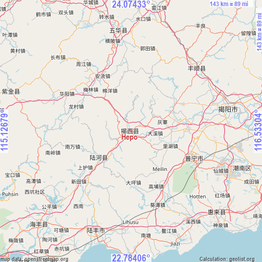
Hepo GPS coordinates[2]
23° 25' 50.772" North, 115° 49' 47.676" East
| Map corner | latitude | longitude |
|---|---|---|
| Upper-left | 24.07433°, | 115.12679° |
| Center: | 23.43077°, | 115.82991° |
| Lower-right: | 22.78406°, | 116.53304° |
| Map W x H: | 143.5×143.5 km | = 89.2×89.2mi |
| max Lat: | 53.31946° ⇑92.5% North |
| Hepo: | 23.43077° |
| min Lat: | ⇓7.5% South 18.22056° |
| min Long | Hepo | max Long |
| 75.07348° | 115.82991° | 134.28917° |
| W 59.1%⇐ | ⇒40.9% E |
Elevation
Elevation of Hepo is 41 m = 135 ft, and this is 443.8 m = 1456 ft below average elevation for this country.
| Max E: |
5622 m = 18445 ft | 73.3% |
| Avg. | 484.8 m = 1591 ft | |
| Hepo | 41 m = 135 ft | |
Min E: |
-3 m = -10 ft | 26.7% |
See also: Hepo elevation on elevation.city.
Geographical zone
Hepo is located in North Torrid zone (between Equator and Tropic of Cancer). Distance of this Northern Tropic circle is 0.7 km =0.4 mi to North.| Distance of | km | miles | from Hepo |
|---|---|---|---|
| North Pole | 7401.8 | 4599.3 | to North |
| Arctic Circle | 4795.9 | 2980 | to North |
| Tropic Cancer | 0.7 | 0.4 | to North |
| Equator | 2605.3 | 1618.9 | to South |


Nearby cities:
15 places around Hepo: (largest is in red/bold)
• Daxi
13.2 km =8.2 mi,  93°
93°
• Dongkeng
21 km =13 mi,  215°
215°
• Hetian
22.8 km =14.2 mi,  230°
230°
• Huizhai
18.8 km =11.7 mi,  70°
70°
• Jinhe
22.6 km =14 mi, 90°
• Liangtian
13.8 km =8.6 mi,  8°
8°
• Lihu
22.9 km =14.2 mi,  109°
109°
• Longtan
5 km =3.1 mi,  63°
63°
• Luoxi
22.4 km =13.9 mi,  254°
254°
• Nanshan
15.5 km =9.6 mi, 64°
• Pingshang
6.9 km =4.3 mi,  117°
117°
• Qiankeng
17.3 km =10.7 mi, 105°
• Shangsha
14.8 km =9.2 mi,  289°
289°
• Shuichun
15.9 km =9.9 mi, 216°
• Wuyun
6.4 km =4 mi, 232°
Sources, notices
• [Note1] Compared only with cities in China existing in our database
• [Src1] Map data: © OpenStreetMap contributors (CC-BY-SA)
• [Src2] Other city data from geonames.org with taken over terms of usage.
• [Src3] Geographical zone / Annual Mean Temperature by Robert A. Rohde @ Wikipedia
