Huanggu geodata
Huanggu (Jiangxi) is a seat of a fourth-order administrative division; located in China in Asia/Shanghai (GMT+8) time zone. In our database, there are 1268 cities with bigger population. Compared to other cities in China, 69.1% of cities are located further ↑North; 70.5% of cities are located further ←West and 60.3% of cities have higher elevation than Huanggu. Note1


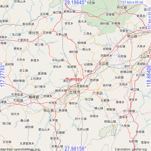
Huanggu GPS coordinates[2]
28° 34' 50.988" North, 117° 58' 51.42" East
| Map corner | latitude | longitude |
|---|---|---|
| Upper-left | 29.19645°, | 117.27783° |
| Center: | 28.58083°, | 117.98095° |
| Lower-right: | 27.96158°, | 118.68408° |
| Map W x H: | 137.3×137.3 km | = 85.3×85.3mi |
| max Lat: | 53.31946° ⇑69.1% North |
| Huanggu: | 28.58083° |
| min Lat: | ⇓30.9% South 18.22056° |
| min Long | Huanggu | max Long |
| 75.07348° | 117.98095° | 134.28917° |
| W 70.5%⇐ | ⇒29.5% E |
Elevation
Elevation of Huanggu is 97 m = 318 ft, and this is 387.8 m = 1272 ft below average elevation for this country.
| Max E: |
5622 m = 18445 ft | 60.3% |
| Avg. | 484.8 m = 1591 ft | |
| Huanggu | 97 m = 318 ft | |
Min E: |
-3 m = -10 ft | 39.7% |
See also: China elevation on elevation.city.
Geographical zone
Huanggu is located in North temperate zone (between Tropic of Cancer and the Arctic Circle). Distance of this Northern Tropic circle is 572 km =355.4 mi to South.| Distance of | km | miles | from Huanggu |
|---|---|---|---|
| North Pole | 6829.2 | 4243.5 | to North |
| Arctic Circle | 4223.3 | 2624.2 | to North |
| Tropic Cancer | 572 | 355.4 | to South |
| Equator | 3177.9 | 1974.7 | to South |


Nearby cities:
15 places around Huanggu: (largest is in red/bold)
• Bimu
15.7 km =9.8 mi,  47°
47°
• Chaoyang
17.5 km =10.9 mi,  150°
150°
• Fenglingtou
18.6 km =11.6 mi,  225°
225°
• Hufeng
20.5 km =12.7 mi,  87°
87°
• Huqiao
17.6 km =10.9 mi,  101°
101°
• Lingxi
10.1 km =6.3 mi, 154°
• Linhu
9.7 km =6 mi,  334°
334°
• Qingshui
10.1 km =6.3 mi,  247°
247°
• Shangrao
14.8 km =9.2 mi,  194°
194°
• Shiren
11.6 km =7.2 mi,  315°
315°
• Shishi
8.8 km =5.5 mi,  184°
184°
• Wangcun
2.4 km =1.5 mi, 318°
• Xiatang
12.2 km =7.6 mi,  71°
71°
• Xuri
17.3 km =10.7 mi,  200°
200°
• Zhengfang
16.1 km =10 mi, 326°
Sources, notices
• [Note1] Compared only with cities in China existing in our database
• [Src1] Map data: © OpenStreetMap contributors (CC-BY-SA)
• [Src2] Other city data from geonames.org with taken over terms of usage.
• [Src3] Geographical zone / Annual Mean Temperature by Robert A. Rohde @ Wikipedia
