Wangcun geodata
Wangcun (Jiangxi) is a seat of a fourth-order administrative division; located in China in Asia/Shanghai (GMT+8) time zone. In our database, there are 1268 cities with bigger population. Compared to other cities in China, 68.9% of cities are located further ↑North; 70.5% of cities are located further ←West and 58.5% of cities have higher elevation than Wangcun. Note1


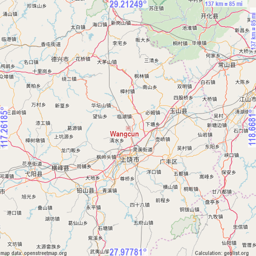
Wangcun GPS coordinates[2]
28° 35' 49.056" North, 117° 57' 53.892" East
| Map corner | latitude | longitude |
|---|---|---|
| Upper-left | 29.21249°, | 117.26185° |
| Center: | 28.59696°, | 117.96497° |
| Lower-right: | 27.97781°, | 118.6681° |
| Map W x H: | 137.3×137.3 km | = 85.3×85.3mi |
| max Lat: | 53.31946° ⇑68.9% North |
| Wangcun: | 28.59696° |
| min Lat: | ⇓31.1% South 18.22056° |
| min Long | Wangcun | max Long |
| 75.07348° | 117.96497° | 134.28917° |
| W 70.5%⇐ | ⇒29.5% E |
Elevation
Elevation of Wangcun is 108 m = 354 ft, and this is 376.8 m = 1236 ft below average elevation for this country.
| Max E: |
5622 m = 18445 ft | 58.5% |
| Avg. | 484.8 m = 1591 ft | |
| Wangcun | 108 m = 354 ft | |
Min E: |
-3 m = -10 ft | 41.5% |
See also: China elevation on elevation.city.
Geographical zone
Wangcun is located in North temperate zone (between Tropic of Cancer and the Arctic Circle). Distance of this Northern Tropic circle is 573.8 km =356.5 mi to South.| Distance of | km | miles | from Wangcun |
|---|---|---|---|
| North Pole | 6827.4 | 4242.3 | to North |
| Arctic Circle | 4221.5 | 2623.1 | to North |
| Tropic Cancer | 573.8 | 356.5 | to South |
| Equator | 3179.7 | 1975.8 | to South |


Nearby cities:
15 places around Wangcun: (largest is in red/bold)
• Bimu
15.8 km =9.8 mi,  55°
55°
• Chaoyang
19.9 km =12.4 mi,  149°
149°
• Fenglingtou
18.9 km =11.7 mi,  218°
218°
• Huanggu
2.4 km =1.5 mi,  138°
138°
• Huatanshan
19.3 km =12 mi,  310°
310°
• Huqiao
19.6 km =12.2 mi,  106°
106°
• Lingxi
12.4 km =7.7 mi, 151°
• Linhu
7.5 km =4.7 mi,  339°
339°
• Qingshui
9.6 km =6 mi,  234°
234°
• Shangrao
16.3 km =10.1 mi,  187°
187°
• Shiren
9.3 km =5.8 mi,  315°
315°
• Shishi
10.6 km =6.6 mi,  175°
175°
• Xiatang
13.3 km =8.3 mi,  81°
81°
• Xuri
18.5 km =11.5 mi, 193°
• Zhengfang
13.7 km =8.5 mi,  327°
327°
Sources, notices
• [Note1] Compared only with cities in China existing in our database
• [Src1] Map data: © OpenStreetMap contributors (CC-BY-SA)
• [Src2] Other city data from geonames.org with taken over terms of usage.
• [Src3] Geographical zone / Annual Mean Temperature by Robert A. Rohde @ Wikipedia
