Hantai geodata
Hantai (Hebei) is a seat of a fourth-order administrative division; located in China in Asia/Shanghai (GMT+8) time zone. In our database, there are 1268 cities with bigger population. Compared to other cities in China, 81.5% of cities are located further ↓South; 53.3% of cities are located further ←West and 67.6% of cities have higher elevation than Hantai. Note1


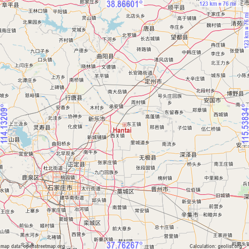
Hantai GPS coordinates[2]
38° 18' 59.184" North, 114° 50' 6.756" East
| Map corner | latitude | longitude |
|---|---|---|
| Upper-left | 38.86601°, | 114.13209° |
| Center: | 38.31644°, | 114.83521° |
| Lower-right: | 37.76267°, | 115.53834° |
| Map W x H: | 122.7×122.7 km | = 76.2×76.2mi |
| max Lat: | 53.31946° ⇑18.5% North |
| Hantai: | 38.31644° |
| min Lat: | ⇓81.5% South 18.22056° |
| min Long | Hantai | max Long |
| 75.07348° | 114.83521° | 134.28917° |
| W 53.3%⇐ | ⇒46.7% E |
Elevation
Elevation of Hantai is 62 m = 203 ft, and this is 422.8 m = 1387 ft below average elevation for this country.
| Max E: |
5622 m = 18445 ft | 67.6% |
| Avg. | 484.8 m = 1591 ft | |
| Hantai | 62 m = 203 ft | |
Min E: |
-3 m = -10 ft | 32.4% |
See also: China elevation on elevation.city.
Geographical zone
Hantai is located in North temperate zone (between Tropic of Cancer and the Arctic Circle). Distance of this Northern Tropic circle is 1654.5 km =1028.1 mi to South.| Distance of | km | miles | from Hantai |
|---|---|---|---|
| North Pole | 5746.7 | 3570.8 | to North |
| Arctic Circle | 3140.8 | 1951.6 | to North |
| Tropic Cancer | 1654.5 | 1028.1 | to South |
| Equator | 4260.4 | 2647.3 | to South |


Nearby cities:
15 places around Hantai: (largest is in red/bold)
• Cheng’an
10 km =6.2 mi,  335°
335°
• Donghoufang
15.9 km =9.9 mi,  159°
159°
• Dugu
9.3 km =5.8 mi,  15°
15°
• Gaopeng
14.4 km =8.9 mi,  73°
73°
• Guozhuang
12 km =7.5 mi,  167°
167°
• Lichengdao
11.9 km =7.4 mi,  139°
139°
• Mingyuedian
16.3 km =10.1 mi, 17°
• Mucun
16.8 km =10.4 mi,  308°
308°
• Nanmeng
13.3 km =8.3 mi,  202°
202°
• Pengjiazhuang
9.5 km =5.9 mi, 310°
• Xiguan
5.8 km =3.6 mi,  215°
215°
• Xinchengpu
14.3 km =8.9 mi,  247°
247°
• Xizhong
9.1 km =5.7 mi,  94°
94°
• Zengcun
11.7 km =7.3 mi,  227°
227°
• Zhoucun
13 km =8.1 mi,  29°
29°
Sources, notices
• [Note1] Compared only with cities in China existing in our database
• [Src1] Map data: © OpenStreetMap contributors (CC-BY-SA)
• [Src2] Other city data from geonames.org with taken over terms of usage.
• [Src3] Geographical zone / Annual Mean Temperature by Robert A. Rohde @ Wikipedia
