Hancheng geodata
Hancheng (Shaanxi) is a populated place; located in China in Asia/Shanghai (GMT+8) time zone. With population of 58,049 people, there are 759 cities with bigger population in this country. Compared to other cities in China, 75.9% of cities are located further ↓South; 69.4% of cities are located further →East and 68.4% of cities have lower elevation than Hancheng. Note1


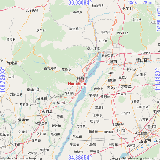
Hancheng GPS coordinates[2]
35° 27' 37.008" North, 110° 25' 45.012" East
| Map corner | latitude | longitude |
|---|---|---|
| Upper-left | 36.03094°, | 109.72605° |
| Center: | 35.46028°, | 110.42917° |
| Lower-right: | 34.88554°, | 111.1323° |
| Map W x H: | 127.4×127.4 km | = 79.2×79.2mi |
| max Lat: | 53.31946° ⇑24.1% North |
| Hancheng: | 35.46028° |
| min Lat: | ⇓75.9% South 18.22056° |
| min Long | Hancheng | max Long |
| 75.07348° | 110.42917° | 134.28917° |
| W 30.6%⇐ | ⇒69.4% E |
Elevation
Elevation of Hancheng is 383 m = 1257 ft, and this is 101.8 m = 334 ft below average elevation for this country.
| Max E: |
5622 m = 18445 ft | 31.6% |
| Avg. | 484.8 m = 1591 ft | |
| Hancheng | 383 m = 1257 ft | |
Min E: |
-3 m = -10 ft | 68.4% |
See also: Hancheng elevation on elevation.city.
Geographical zone
Hancheng is located in North temperate zone (between Tropic of Cancer and the Arctic Circle). Distance of this Northern Tropic circle is 1336.9 km =830.7 mi to South.| Distance of | km | miles | from Hancheng |
|---|---|---|---|
| North Pole | 6064.2 | 3768.1 | to North |
| Arctic Circle | 3458.4 | 2148.9 | to North |
| Tropic Cancer | 1336.9 | 830.7 | to South |
| Equator | 3942.8 | 2449.9 | to South |


Nearby cities:
15 places around Hancheng: (largest is in red/bold)
• Beizhang
66.6 km =41.4 mi,  66°
66°
• Changning
67.8 km =42.1 mi,  31°
31°
• Guojiazhuang
68.7 km =42.7 mi,  104°
104°
• Jifeng
50.8 km =31.6 mi, 70°
• Sanquan
70.1 km =43.6 mi, 70°
• Shangyuan
65.9 km =40.9 mi, 74°
• Shenbai
66 km =41 mi, 99°
• Wan’an
63.9 km =39.7 mi,  81°
81°
• Xiedian
34.8 km =21.6 mi, 95°
• Xuedian
69.8 km =43.4 mi,  89°
89°
• Yangwang
62.3 km =38.7 mi, 85°
• Yangyu
60.1 km =37.3 mi, 94°
• Yishi
43.6 km =27.1 mi,  138°
138°
• Yuncheng
70.6 km =43.9 mi,  133°
133°
• Zhongwadi
65.5 km =40.7 mi, 91°
Sources, notices
• [Note1] Compared only with cities in China existing in our database
• [Src1] Map data: © OpenStreetMap contributors (CC-BY-SA)
• [Src2] Other city data from geonames.org with taken over terms of usage.
• [Src3] Geographical zone / Annual Mean Temperature by Robert A. Rohde @ Wikipedia
