Yuncheng geodata
Yuncheng (Shanxi) is a populated place; located in China in Asia/Shanghai (GMT+8) time zone. With population of 201,950 people, there are 230 cities with bigger population in this country. Compared to other cities in China, 75.1% of cities are located further ↓South; 67% of cities are located further →East and 67.1% of cities have lower elevation than Yuncheng. Note1


Yuncheng GPS coordinates[2]
35° 1' 23.016" North, 110° 59' 34.008" East
| Map corner | latitude | longitude |
|---|---|---|
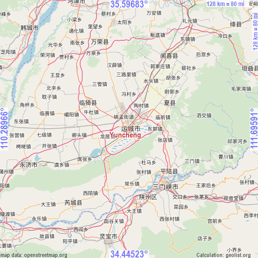
| Upper-left | 35.59683°, | 110.28966° |
| Center: | 35.02306°, | 110.99278° |
| Lower-right: | 34.44523°, | 111.69591° |
| Map W x H: | 128×128 km | = 79.5×79.5mi |
| max Lat: | 53.31946° ⇑24.9% North |
| Yuncheng: | 35.02306° |
| min Lat: | ⇓75.1% South 18.22056° |
| min Long | Yuncheng | max Long |
| 75.07348° | 110.99278° | 134.28917° |
| W 33%⇐ | ⇒67% E |
Elevation
Elevation of Yuncheng is 361 m = 1184 ft, and this is 123.8 m = 406 ft below average elevation for this country.
| Max E: |
5622 m = 18445 ft | 32.9% |
| Avg. | 484.8 m = 1591 ft | |
| Yuncheng | 361 m = 1184 ft | |
Min E: |
-3 m = -10 ft | 67.1% |
See also: Yuncheng elevation on elevation.city.
Geographical zone
Yuncheng is located in North temperate zone (between Tropic of Cancer and the Arctic Circle). Distance of this Northern Tropic circle is 1288.3 km =800.5 mi to South.| Distance of | km | miles | from Yuncheng |
|---|---|---|---|
| North Pole | 6112.9 | 3798.4 | to North |
| Arctic Circle | 3507 | 2179.1 | to North |
| Tropic Cancer | 1288.3 | 800.5 | to South |
| Equator | 3894.2 | 2419.7 | to South |


Nearby cities:
15 places around Yuncheng: (largest is in red/bold)
• Anyi
5.2 km =3.2 mi,  45°
45°
• Daying
35 km =21.7 mi,  163°
163°
• Guojiazhuang
34.9 km =21.7 mi,  26°
26°
• Guwei
46.3 km =28.8 mi,  221°
221°
• Hedi
47.8 km =29.7 mi,  43°
43°
• Hougong
52.4 km =32.6 mi, 44°
• Peishe
42.5 km =26.4 mi, 44°
• Shenbai
40.7 km =25.3 mi,  20°
20°
• Shengrenjian
26.9 km =16.7 mi,  137°
137°
• Tongcheng
42.1 km =26.2 mi, 28°
• Xiedian
47.9 km =29.8 mi,  339°
339°
• Yangyu
45 km =28 mi,  11°
11°
• Yaofeng
23.7 km =14.7 mi,  57°
57°
• Yishi
27.4 km =17 mi,  305°
305°
• Zhongwadi
48.9 km =30.4 mi, 17°
Sources, notices
• [Note1] Compared only with cities in China existing in our database
• [Src1] Map data: © OpenStreetMap contributors (CC-BY-SA)
• [Src2] Other city data from geonames.org with taken over terms of usage.
• [Src3] Geographical zone / Annual Mean Temperature by Robert A. Rohde @ Wikipedia
