Guhuai geodata
Guhuai (Fujian) is a seat of a fourth-order administrative division; located in China in Asia/Shanghai (GMT+8) time zone. In our database, there are 1268 cities with bigger population. Compared to other cities in China, 82.9% of cities are located further ↑North; 79% of cities are located further ←West and 82.9% of cities have higher elevation than Guhuai. Note1


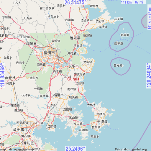
Guhuai GPS coordinates[2]
25° 53' 1.932" North, 119° 32' 16.116" East
| Map corner | latitude | longitude |
|---|---|---|
| Upper-left | 26.51475°, | 118.83469° |
| Center: | 25.88387°, | 119.53781° |
| Lower-right: | 25.2496°, | 120.24094° |
| Map W x H: | 140.7×140.7 km | = 87.4×87.4mi |
| max Lat: | 53.31946° ⇑82.9% North |
| Guhuai: | 25.88387° |
| min Lat: | ⇓17.1% South 18.22056° |
| min Long | Guhuai | max Long |
| 75.07348° | 119.53781° | 134.28917° |
| W 79%⇐ | ⇒21% E |
Elevation
Elevation of Guhuai is 20 m = 66 ft, and this is 464.8 m = 1525 ft below average elevation for this country.
| Max E: |
5622 m = 18445 ft | 82.9% |
| Avg. | 484.8 m = 1591 ft | |
| Guhuai | 20 m = 66 ft | |
Min E: |
-3 m = -10 ft | 17.1% |
See also: China elevation on elevation.city.
Geographical zone
Guhuai is located in North temperate zone (between Tropic of Cancer and the Arctic Circle). Distance of this Northern Tropic circle is 272.1 km =169.1 mi to South.| Distance of | km | miles | from Guhuai |
|---|---|---|---|
| North Pole | 7129 | 4429.8 | to North |
| Arctic Circle | 4523.2 | 2810.6 | to North |
| Tropic Cancer | 272.1 | 169.1 | to South |
| Equator | 2878 | 1788.3 | to South |


Nearby cities:
15 places around Guhuai: (largest is in red/bold)
• Heshang
7.5 km =4.7 mi,  8°
8°
• Hunan
14.5 km =9 mi,  47°
47°
• Jiangtian
8.1 km =5 mi,  152°
152°
• Jinfeng
13.6 km =8.5 mi,  38°
38°
• Luolian
7.6 km =4.7 mi,  245°
245°
• Minjiang
16.7 km =10.4 mi,  298°
298°
• Nanling
13.2 km =8.2 mi,  198°
198°
• Qingkou
15.2 km =9.4 mi,  274°
274°
• Shouzhan
8.4 km =5.2 mi,  316°
316°
• Songxia
14.4 km =8.9 mi,  157°
157°
• Wenwusha
4.1 km =2.5 mi,  65°
65°
• Xiangqian
16.5 km =10.3 mi,  293°
293°
• Yingqian
11.9 km =7.4 mi, 321°
• Yutian
8.7 km =5.4 mi,  263°
263°
• Zhanggang
10 km =6.2 mi,  63°
63°
Sources, notices
• [Note1] Compared only with cities in China existing in our database
• [Src1] Map data: © OpenStreetMap contributors (CC-BY-SA)
• [Src2] Other city data from geonames.org with taken over terms of usage.
• [Src3] Geographical zone / Annual Mean Temperature by Robert A. Rohde @ Wikipedia
