Minjiang geodata
Minjiang (Fujian) is a seat of a fourth-order administrative division; located in China in Asia/Shanghai (GMT+8) time zone. In our database, there are 1268 cities with bigger population. Compared to other cities in China, 82.5% of cities are located further ↑North; 78.1% of cities are located further ←West and 89.9% of cities have higher elevation than Minjiang. Note1


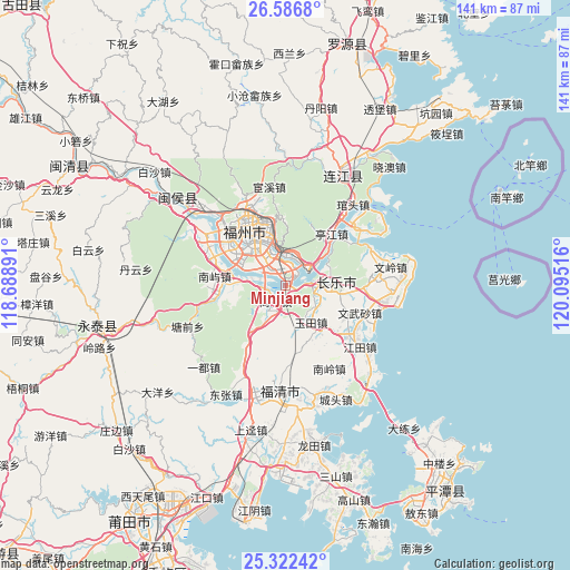
Minjiang GPS coordinates[2]
25° 57' 22.716" North, 119° 23' 31.308" East
| Map corner | latitude | longitude |
|---|---|---|
| Upper-left | 26.5868°, | 118.68891° |
| Center: | 25.95631°, | 119.39203° |
| Lower-right: | 25.32242°, | 120.09516° |
| Map W x H: | 140.6×140.6 km | = 87.4×87.4mi |
| max Lat: | 53.31946° ⇑82.5% North |
| Minjiang: | 25.95631° |
| min Lat: | ⇓17.5% South 18.22056° |
| min Long | Minjiang | max Long |
| 75.07348° | 119.39203° | 134.28917° |
| W 78.1%⇐ | ⇒21.9% E |
Elevation
Elevation of Minjiang is 10 m = 33 ft, and this is 474.8 m = 1558 ft below average elevation for this country.
| Max E: |
5622 m = 18445 ft | 89.9% |
| Avg. | 484.8 m = 1591 ft | |
| Minjiang | 10 m = 33 ft | |
Min E: |
-3 m = -10 ft | 10.1% |
See also: China elevation on elevation.city.
Geographical zone
Minjiang is located in North temperate zone (between Tropic of Cancer and the Arctic Circle). Distance of this Northern Tropic circle is 280.2 km =174.1 mi to South.| Distance of | km | miles | from Minjiang |
|---|---|---|---|
| North Pole | 7121 | 4424.8 | to North |
| Arctic Circle | 4515.1 | 2805.6 | to North |
| Tropic Cancer | 280.2 | 174.1 | to South |
| Equator | 2886.1 | 1793.3 | to South |


Nearby cities:
15 places around Minjiang: (largest is in red/bold)
• Cangshan
12.4 km =7.7 mi,  317°
317°
• Chengmen
5.1 km =3.2 mi, 323°
• Fuzhou
14.5 km =9 mi, 323°
• Gaishan
9.8 km =6.1 mi, 320°
• Gushan
13.9 km =8.6 mi,  339°
339°
• Kuai’an
9 km =5.6 mi,  15°
15°
• Luolian
13.5 km =8.4 mi,  145°
145°
• Luozhou
5.8 km =3.6 mi,  304°
304°
• Nantong
14.1 km =8.8 mi,  261°
261°
• Qingkou
6.9 km =4.3 mi,  184°
184°
• Shanggan
3.9 km =2.4 mi,  214°
214°
• Shouzhan
9 km =5.6 mi,  102°
102°
• Xiangqian
1.7 km =1.1 mi,  201°
201°
• Yingqian
7.2 km =4.5 mi,  80°
80°
• Yutian
10.9 km =6.8 mi, 146°
Sources, notices
• [Note1] Compared only with cities in China existing in our database
• [Src1] Map data: © OpenStreetMap contributors (CC-BY-SA)
• [Src2] Other city data from geonames.org with taken over terms of usage.
• [Src3] Geographical zone / Annual Mean Temperature by Robert A. Rohde @ Wikipedia
