Gucun geodata
Gucun (Jiangxi) is a seat of a fourth-order administrative division; located in China in Asia/Shanghai (GMT+8) time zone. In our database, there are 1268 cities with bigger population. Compared to other cities in China, 81.4% of cities are located further ↑North; 60.9% of cities are located further ←West and 54.3% of cities have lower elevation than Gucun. Note1


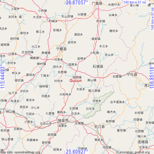
Gucun GPS coordinates[2]
26° 14' 29.868" North, 116° 8' 52.98" East
| Map corner | latitude | longitude |
|---|---|---|
| Upper-left | 26.87057°, | 115.44493° |
| Center: | 26.24163°, | 116.14805° |
| Lower-right: | 25.60927°, | 116.85118° |
| Map W x H: | 140.2×140.2 km | = 87.1×87.1mi |
| max Lat: | 53.31946° ⇑81.4% North |
| Gucun: | 26.24163° |
| min Lat: | ⇓18.6% South 18.22056° |
| min Long | Gucun | max Long |
| 75.07348° | 116.14805° | 134.28917° |
| W 60.9%⇐ | ⇒39.1% E |
Elevation
Elevation of Gucun is 200 m = 656 ft, and this is 284.8 m = 934 ft below average elevation for this country.
| Max E: |
5622 m = 18445 ft | 45.7% |
| Avg. | 484.8 m = 1591 ft | |
| Gucun | 200 m = 656 ft | |
Min E: |
-3 m = -10 ft | 54.3% |
See also: China elevation on elevation.city.
Geographical zone
Gucun is located in North temperate zone (between Tropic of Cancer and the Arctic Circle). Distance of this Northern Tropic circle is 311.9 km =193.8 mi to South.| Distance of | km | miles | from Gucun |
|---|---|---|---|
| North Pole | 7089.3 | 4405.1 | to North |
| Arctic Circle | 4483.4 | 2785.9 | to North |
| Tropic Cancer | 311.9 | 193.8 | to South |
| Equator | 2917.8 | 1813 | to South |


Nearby cities:
15 places around Gucun: (largest is in red/bold)
• Changsheng
14.3 km =8.9 mi,  289°
289°
• Dabaidi
18.8 km =11.7 mi,  214°
214°
• Dayou
11.3 km =7 mi,  162°
162°
• Duifang
17.2 km =10.7 mi,  259°
259°
• Guhou
12.2 km =7.6 mi,  341°
341°
• Hengjiang
22.8 km =14.2 mi,  118°
118°
• Huangshi
21.3 km =13.2 mi,  270°
270°
• Longgang
18.5 km =11.5 mi,  142°
142°
• Pingshan
13.7 km =8.5 mi,  100°
100°
• Qinjiang
21 km =13 mi,  62°
62°
• Tianbu
17.6 km =10.9 mi,  13°
13°
• Xiaosong
27.3 km =17 mi,  35°
35°
• Yangdi
28 km =17.4 mi, 140°
• Zhukeng
21.5 km =13.4 mi, 97°
• Zhuzuo
23.3 km =14.5 mi,  313°
313°
Sources, notices
• [Note1] Compared only with cities in China existing in our database
• [Src1] Map data: © OpenStreetMap contributors (CC-BY-SA)
• [Src2] Other city data from geonames.org with taken over terms of usage.
• [Src3] Geographical zone / Annual Mean Temperature by Robert A. Rohde @ Wikipedia
