Guangfuqiao geodata
Guangfuqiao (Hunan) is a seat of a fourth-order administrative division; located in China in Asia/Shanghai (GMT+8) time zone. In our database, there are 1268 cities with bigger population. Compared to other cities in China, 60% of cities are located further ↑North; 65.9% of cities are located further →East and 53.7% of cities have higher elevation than Guangfuqiao. Note1


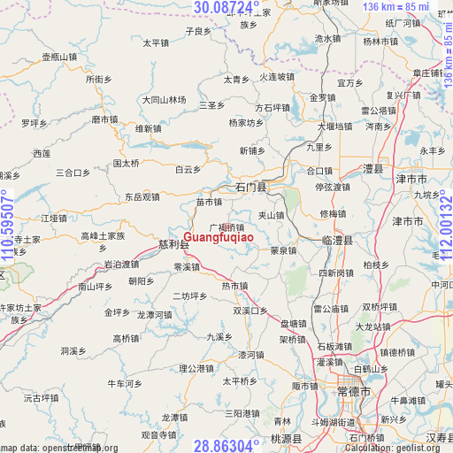
Guangfuqiao GPS coordinates[2]
29° 28' 37.164" North, 111° 17' 53.484" East
| Map corner | latitude | longitude |
|---|---|---|
| Upper-left | 30.08724°, | 110.59507° |
| Center: | 29.47699°, | 111.29819° |
| Lower-right: | 28.86304°, | 112.00132° |
| Map W x H: | 136.1×136.1 km | = 84.6×84.6mi |
| max Lat: | 53.31946° ⇑60% North |
| Guangfuqiao: | 29.47699° |
| min Lat: | ⇓40% South 18.22056° |
| min Long | Guangfuqiao | max Long |
| 75.07348° | 111.29819° | 134.28917° |
| W 34.1%⇐ | ⇒65.9% E |
Elevation
Elevation of Guangfuqiao is 139 m = 456 ft, and this is 345.8 m = 1135 ft below average elevation for this country.
| Max E: |
5622 m = 18445 ft | 53.7% |
| Avg. | 484.8 m = 1591 ft | |
| Guangfuqiao | 139 m = 456 ft | |
Min E: |
-3 m = -10 ft | 46.3% |
See also: China elevation on elevation.city.
Geographical zone
Guangfuqiao is located in North temperate zone (between Tropic of Cancer and the Arctic Circle). Distance of this Northern Tropic circle is 671.6 km =417.3 mi to South.| Distance of | km | miles | from Guangfuqiao |
|---|---|---|---|
| North Pole | 6729.5 | 4181.5 | to North |
| Arctic Circle | 4123.6 | 2562.3 | to North |
| Tropic Cancer | 671.6 | 417.3 | to South |
| Equator | 3277.5 | 2036.5 | to South |


Nearby cities:
15 places around Guangfuqiao: (largest is in red/bold)
• Baiyun
21 km =13 mi,  326°
326°
• Chujiang
12.8 km =8 mi,  29°
29°
• Cili
18.2 km =11.3 mi,  251°
251°
• Erdu
16.3 km =10.1 mi,  39°
39°
• Erfangping
23.3 km =14.5 mi,  205°
205°
• Haoping
22.6 km =14 mi,  186°
186°
• Jiashan
14 km =8.7 mi,  75°
75°
• Lingxi
16.8 km =10.4 mi,  225°
225°
• Mengquan
18.5 km =11.5 mi,  112°
112°
• Miaoshi
9.2 km =5.7 mi,  324°
324°
• Reshi
17.5 km =10.9 mi,  172°
172°
• Sheshiqiao
21.6 km =13.4 mi,  100°
100°
• Xinguan
15.9 km =9.9 mi,  3°
3°
• Yanliupu
19.4 km =12.1 mi,  301°
301°
• Zaoshi
20.6 km =12.8 mi,  342°
342°
Sources, notices
• [Note1] Compared only with cities in China existing in our database
• [Src1] Map data: © OpenStreetMap contributors (CC-BY-SA)
• [Src2] Other city data from geonames.org with taken over terms of usage.
• [Src3] Geographical zone / Annual Mean Temperature by Robert A. Rohde @ Wikipedia
