Erfangping geodata
Erfangping (Hunan) is a seat of a fourth-order administrative division; located in China in Asia/Shanghai (GMT+8) time zone. In our database, there are 1268 cities with bigger population. Compared to other cities in China, 62.1% of cities are located further ↑North; 66.3% of cities are located further →East and 54.8% of cities have higher elevation than Erfangping. Note1


Erfangping GPS coordinates[2]
29° 17' 17.988" North, 111° 11' 38.004" East
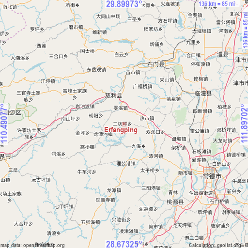
| Map corner | latitude | longitude |
|---|---|---|
| Upper-left | 29.89973°, | 110.49077° |
| Center: | 29.28833°, | 111.19389° |
| Lower-right: | 28.67325°, | 111.89702° |
| Map W x H: | 136.4×136.4 km | = 84.8×84.8mi |
| max Lat: | 53.31946° ⇑62.1% North |
| Erfangping: | 29.28833° |
| min Lat: | ⇓37.9% South 18.22056° |
| min Long | Erfangping | max Long |
| 75.07348° | 111.19389° | 134.28917° |
| W 33.7%⇐ | ⇒66.3% E |
Elevation
Elevation of Erfangping is 133 m = 436 ft, and this is 351.8 m = 1154 ft below average elevation for this country.
| Max E: |
5622 m = 18445 ft | 54.8% |
| Avg. | 484.8 m = 1591 ft | |
| Erfangping | 133 m = 436 ft | |
Min E: |
-3 m = -10 ft | 45.2% |
See also: China elevation on elevation.city.
Geographical zone
Erfangping is located in North temperate zone (between Tropic of Cancer and the Arctic Circle). Distance of this Northern Tropic circle is 650.6 km =404.3 mi to South.| Distance of | km | miles | from Erfangping |
|---|---|---|---|
| North Pole | 6750.5 | 4194.6 | to North |
| Arctic Circle | 4144.6 | 2575.3 | to North |
| Tropic Cancer | 650.6 | 404.3 | to South |
| Equator | 3256.6 | 2023.6 | to South |


Nearby cities:
15 places around Erfangping: (largest is in red/bold)
• Chaoyang
16.7 km =10.4 mi,  288°
288°
• Cili
16.7 km =10.4 mi,  334°
334°
• Gaoqiao
23.7 km =14.7 mi,  237°
237°
• Guangfuqiao
23.3 km =14.5 mi,  25°
25°
• Haoping
7.7 km =4.8 mi,  101°
101°
• Huangjiapu
21.5 km =13.4 mi,  154°
154°
• Huangshi
11.8 km =7.3 mi,  179°
179°
• Jinglongqiao
9.5 km =5.9 mi,  279°
279°
• Jinping
23.3 km =14.5 mi,  258°
258°
• Jiuxi
14.1 km =8.8 mi, 147°
• Ligonggang
21.5 km =13.4 mi, 178°
• Lingxi
9.4 km =5.8 mi,  348°
348°
• Longtanhe
12.5 km =7.8 mi,  246°
246°
• Reshi
13 km =8.1 mi,  73°
73°
• Shuangxikou
17.3 km =10.7 mi, 104°
Sources, notices
• [Note1] Compared only with cities in China existing in our database
• [Src1] Map data: © OpenStreetMap contributors (CC-BY-SA)
• [Src2] Other city data from geonames.org with taken over terms of usage.
• [Src3] Geographical zone / Annual Mean Temperature by Robert A. Rohde @ Wikipedia
