Geyuan geodata
Geyuan (Jiangxi) is a seat of a fourth-order administrative division; located in China in Asia/Shanghai (GMT+8) time zone. In our database, there are 1268 cities with bigger population. Compared to other cities in China, 68.8% of cities are located further ↑North; 69.4% of cities are located further ←West and 53.5% of cities have higher elevation than Geyuan. Note1


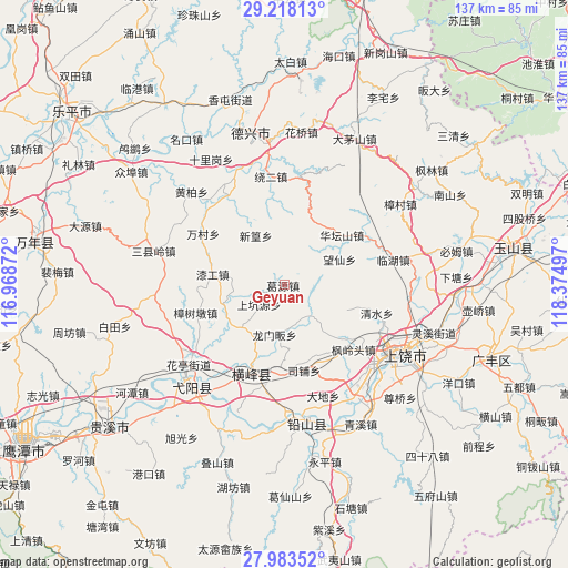
Geyuan GPS coordinates[2]
28° 36' 9.504" North, 117° 40' 18.624" East
| Map corner | latitude | longitude |
|---|---|---|
| Upper-left | 29.21813°, | 116.96872° |
| Center: | 28.60264°, | 117.67184° |
| Lower-right: | 27.98352°, | 118.37497° |
| Map W x H: | 137.3×137.3 km | = 85.3×85.3mi |
| max Lat: | 53.31946° ⇑68.8% North |
| Geyuan: | 28.60264° |
| min Lat: | ⇓31.2% South 18.22056° |
| min Long | Geyuan | max Long |
| 75.07348° | 117.67184° | 134.28917° |
| W 69.4%⇐ | ⇒30.6% E |
Elevation
Elevation of Geyuan is 140 m = 459 ft, and this is 344.8 m = 1131 ft below average elevation for this country.
| Max E: |
5622 m = 18445 ft | 53.5% |
| Avg. | 484.8 m = 1591 ft | |
| Geyuan | 140 m = 459 ft | |
Min E: |
-3 m = -10 ft | 46.5% |
See also: China elevation on elevation.city.
Geographical zone
Geyuan is located in North temperate zone (between Tropic of Cancer and the Arctic Circle). Distance of this Northern Tropic circle is 574.4 km =356.9 mi to South.| Distance of | km | miles | from Geyuan |
|---|---|---|---|
| North Pole | 6826.7 | 4241.9 | to North |
| Arctic Circle | 4220.9 | 2622.7 | to North |
| Tropic Cancer | 574.4 | 356.9 | to South |
| Equator | 3180.3 | 1976.1 | to South |


Nearby cities:
15 places around Geyuan: (largest is in red/bold)
• Fenglingtou
23 km =14.3 mi,  132°
132°
• Gangbian
15.2 km =9.4 mi,  173°
173°
• Huatanshan
18.4 km =11.4 mi,  49°
49°
• Lieqiao
15.2 km =9.4 mi,  253°
253°
• Lingyang
20.9 km =13 mi,  197°
197°
• Longmenfan
11.5 km =7.1 mi,  190°
190°
• Puqian
15.5 km =9.6 mi, 201°
• Qingban
14.2 km =8.8 mi,  223°
223°
• Qingban
16.6 km =10.3 mi,  234°
234°
• Qingshui
21.8 km =13.5 mi,  106°
106°
• Shiren
22.8 km =14.2 mi,  74°
74°
• Sipu
18.9 km =11.7 mi, 169°
• Wancun
23 km =14.3 mi,  302°
302°
• Xinhuang
14.1 km =8.8 mi,  330°
330°
• Zhangcun
20.6 km =12.8 mi, 328°
Sources, notices
• [Note1] Compared only with cities in China existing in our database
• [Src1] Map data: © OpenStreetMap contributors (CC-BY-SA)
• [Src2] Other city data from geonames.org with taken over terms of usage.
• [Src3] Geographical zone / Annual Mean Temperature by Robert A. Rohde @ Wikipedia
