Shiren geodata
Shiren (Jiangxi) is a seat of a fourth-order administrative division; located in China in Asia/Shanghai (GMT+8) time zone. In our database, there are 1268 cities with bigger population. Compared to other cities in China, 68.4% of cities are located further ↑North; 70.2% of cities are located further ←West and 54% of cities have higher elevation than Shiren. Note1


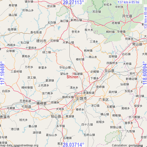
Shiren GPS coordinates[2]
28° 39' 21.42" North, 117° 53' 52.116" East
| Map corner | latitude | longitude |
|---|---|---|
| Upper-left | 29.27113°, | 117.19469° |
| Center: | 28.65595°, | 117.89781° |
| Lower-right: | 28.03714°, | 118.60094° |
| Map W x H: | 137.2×137.2 km | = 85.3×85.3mi |
| max Lat: | 53.31946° ⇑68.4% North |
| Shiren: | 28.65595° |
| min Lat: | ⇓31.6% South 18.22056° |
| min Long | Shiren | max Long |
| 75.07348° | 117.89781° | 134.28917° |
| W 70.2%⇐ | ⇒29.8% E |
Elevation
Elevation of Shiren is 137 m = 449 ft, and this is 347.8 m = 1141 ft below average elevation for this country.
| Max E: |
5622 m = 18445 ft | 54% |
| Avg. | 484.8 m = 1591 ft | |
| Shiren | 137 m = 449 ft | |
Min E: |
-3 m = -10 ft | 46% |
See also: China elevation on elevation.city.
Geographical zone
Shiren is located in North temperate zone (between Tropic of Cancer and the Arctic Circle). Distance of this Northern Tropic circle is 580.3 km =360.6 mi to South.| Distance of | km | miles | from Shiren |
|---|---|---|---|
| North Pole | 6820.8 | 4238.2 | to North |
| Arctic Circle | 4214.9 | 2619 | to North |
| Tropic Cancer | 580.3 | 360.6 | to South |
| Equator | 3186.2 | 1979.8 | to South |


Nearby cities:
15 places around Shiren: (largest is in red/bold)
• Bimu
19.8 km =12.3 mi,  83°
83°
• Fenglingtou
22 km =13.7 mi,  193°
193°
• Geyuan
22.8 km =14.2 mi,  254°
254°
• Hengjie
24.5 km =15.2 mi, 77°
• Huanggu
11.6 km =7.2 mi,  135°
135°
• Huatanshan
10.1 km =6.3 mi,  307°
307°
• Lingxi
21.5 km =13.4 mi, 144°
• Linhu
3.9 km =2.4 mi, 84°
• Nanshan
24.6 km =15.3 mi,  48°
48°
• Qingshui
12.2 km =7.6 mi, 185°
• Shangrao
23.1 km =14.4 mi,  169°
169°
• Shishi
18.7 km =11.6 mi,  156°
156°
• Wangcun
9.3 km =5.8 mi, 135°
• Xiatang
20.2 km =12.6 mi,  102°
102°
• Zhengfang
5.1 km =3.2 mi,  350°
350°
Sources, notices
• [Note1] Compared only with cities in China existing in our database
• [Src1] Map data: © OpenStreetMap contributors (CC-BY-SA)
• [Src2] Other city data from geonames.org with taken over terms of usage.
• [Src3] Geographical zone / Annual Mean Temperature by Robert A. Rohde @ Wikipedia
