Gaoqiao geodata
Gaoqiao (Gansu) is a seat of a fourth-order administrative division; located in China in Asia/Shanghai (GMT+8) time zone. In our database, there are 1268 cities with bigger population. Compared to other cities in China, 70.6% of cities are located further ↓South; 87.1% of cities are located further →East and 89.8% of cities have lower elevation than Gaoqiao. Note1


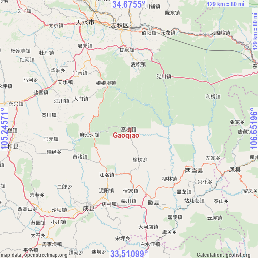
Gaoqiao GPS coordinates[2]
34° 5' 42.9" North, 105° 56' 55.788" East
| Map corner | latitude | longitude |
|---|---|---|
| Upper-left | 34.6755°, | 105.24571° |
| Center: | 34.09525°, | 105.94883° |
| Lower-right: | 33.51099°, | 106.65196° |
| Map W x H: | 129.5×129.5 km | = 80.5×80.5mi |
| max Lat: | 53.31946° ⇑29.4% North |
| Gaoqiao: | 34.09525° |
| min Lat: | ⇓70.6% South 18.22056° |
| min Long | Gaoqiao | max Long |
| 75.07348° | 105.94883° | 134.28917° |
| W 12.9%⇐ | ⇒87.1% E |
Elevation
Elevation of Gaoqiao is 1341 m = 4400 ft, and this is 856.2 m = 2809 ft above average elevation for this country.
| Max E: |
5622 m = 18445 ft | 10.2% |
| Gaoqiao | 1341 m 4400 ft | |
| Avg. | 484.8 m = 1591 ft | |
Min E: |
-3 m = -10 ft | 89.8% |
See also: China elevation on elevation.city.
Geographical zone
Gaoqiao is located in North temperate zone (between Tropic of Cancer and the Arctic Circle). Distance of this Northern Tropic circle is 1185.1 km =736.4 mi to South.| Distance of | km | miles | from Gaoqiao |
|---|---|---|---|
| North Pole | 6216 | 3862.4 | to North |
| Arctic Circle | 3610.1 | 2243.2 | to North |
| Tropic Cancer | 1185.1 | 736.4 | to South |
| Equator | 3791 | 2355.6 | to South |


Nearby cities:
15 places around Gaoqiao: (largest is in red/bold)
• Fujia
30.7 km =19.1 mi,  179°
179°
• Huangzhu
28.3 km =17.6 mi,  239°
239°
• Jiangluo
24.5 km =15.2 mi,  208°
208°
• Liulin
31.9 km =19.8 mi,  140°
140°
• Mayanhe
19.7 km =12.2 mi,  262°
262°
• Niyang
32.8 km =20.4 mi,  200°
200°
• Shuiquan
37.9 km =23.5 mi, 213°
• Suchuan
34.1 km =21.2 mi, 179°
• Taibai
20.1 km =12.5 mi,  101°
101°
• Taiyang
31.9 km =19.8 mi,  93°
93°
• Wangmo
37 km =23 mi,  222°
222°
• Yinxingshu
33.3 km =20.7 mi,  165°
165°
• Yongning
36 km =22.4 mi, 142°
• Youlongchuan
23.8 km =14.8 mi, 195°
• Yushu
15.9 km =9.9 mi,  160°
160°
Sources, notices
• [Note1] Compared only with cities in China existing in our database
• [Src1] Map data: © OpenStreetMap contributors (CC-BY-SA)
• [Src2] Other city data from geonames.org with taken over terms of usage.
• [Src3] Geographical zone / Annual Mean Temperature by Robert A. Rohde @ Wikipedia
